

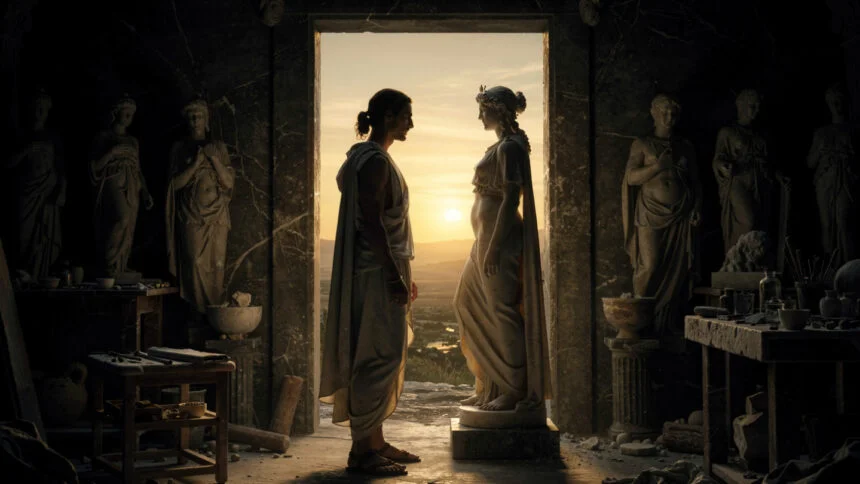
Crete is the place where Europe’s first civilization buried its dead, built its palaces, and pressed its oil.
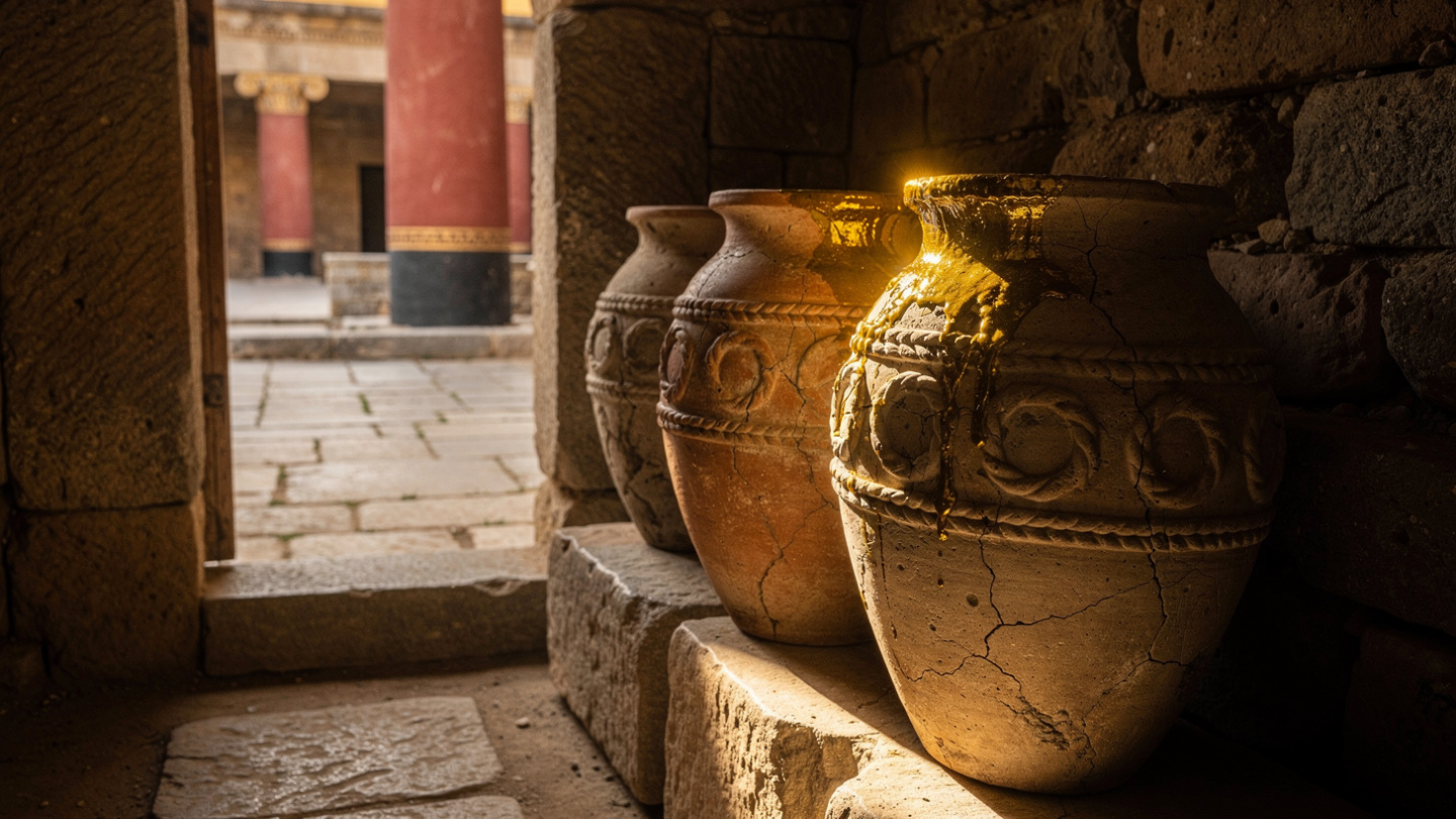
That sequence, burial, palace, oil, is not a random list. It is the index of a civilization that the Minoans developed on this island between approximately 3000 and 1450 BCE, before mainland Greece had produced anything comparable, before the great sanctuaries of the classical period existed, before the alphabet in which the myths were eventually written had been invented. The Minoans built at Knossos a palace complex of over a thousand rooms. They established trade networks that connected Crete to Egypt, the Levant, and the Aegean islands. They produced the first writing system in Europe. They made olive oil in quantities sufficient to trade internationally and stored it in the great ceramic jars, the pithoi, that still stand in the palace storerooms.
When this civilization collapsed, around 1450 BCE, in circumstances that the archaeological record preserves but does not explain with complete clarity, it left behind a landscape so saturated with the evidence of what had been done here that every subsequent inhabitant of the island has lived on top of it. The Romans built their provincial capital at Gortyna, on the site of a Minoan settlement. The Venetians built their fortifications at Heraklion and Chania over the remains of earlier harbors. The contemporary villages of the Lasithi plateau and the mountain communities of the White Mountains maintain agricultural rhythms that the Minoan palace economy had organized and managed.
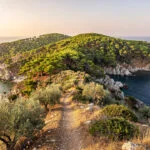
Crete is the largest Greek island, the fifth largest in the Mediterranean, 260 kilometers long and between 12 and 60 kilometers wide. It spans everything from the Aegean coast in the north to the Libyan Sea in the south, from the palm beach at Vai in the east to the lagoon at Balos in the west. Its terrain is dominated by three mountain ranges. The White Mountains are in the west and their highest point exceeds 2450 meters. Mount Ida is in the center, where the cave in which Zeus was born or hidden in the mythological accounts still receives visitors who make the ascent. The Dikti range is in the east and holds the Dikteon cave, another candidate for the same divine birth story in a different regional narrative.
What follows is an account of the island organized around the qualities of each region and each site, written for the traveler who wants to understand what they are looking at rather than simply confirm that it matches the photograph.
Heraklion and the Weight of the Record
The capital of Crete is not the island’s most beautiful city, but it is the city that holds the most concentrated access to what Crete was before any other European civilization existed.
The Archaeological Museum of Heraklion, rebuilt in its current form and reopened in stages across the early twenty-first century, contains the material record of Minoan civilization in the form in which no other museum can match: the objects recovered from Knossos, from Phaistos, from Akrotiri, from the palace sites and the tombs and the harbor settlements of the island, displayed in the sequence and at the scale that allows the visitor to understand what the Minoans were making and why.
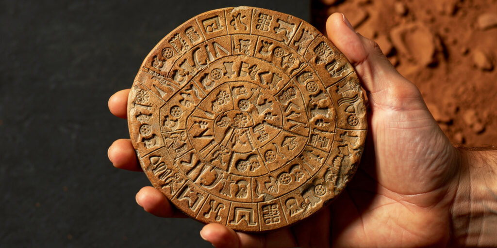
The Phaistos Disc is here: a fired clay disc approximately fifteen centimeters in diameter, impressed on both sides with forty-five distinct signs arranged in a spiral, dated to the Middle Minoan period. It remains undeciphered. No other object bears the same signs. Whether it is a text, a list, a ritual object, or something else entirely, the scholarly literature has not established, and the disc continues to be the most discussed undeciphered document in European archaeology.
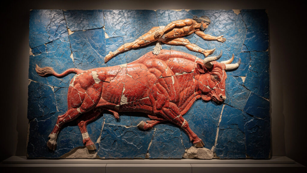
The bull-leaping fresco from Knossos is here, in the form of the restored original fragments and the reconstruction that makes the scene legible: a figure in the act of vaulting over the back of a bull in full charge, the trajectory of the leap implying a relationship between the human body and the animal that was either genuinely practiced, as athletic performance or ritual, or represented in the visual culture as an ideal whose physical execution may have been symbolic rather than literal.
The gold ring known as the Ring of Minos is here. The snake goddess figurines are here. The Linear A tablets, still undeciphered in the same way that the Phaistos Disc is undeciphered, are here. The full scope of what the Minoans produced in their three centuries of maximum activity is concentrated in this building, and the visit requires time measured in hours rather than in minutes if what the visitor wants is to understand the civilization rather than to pass through its artifacts.
The Palace of Knossos is three kilometers south of the city, accessible by bus or by taxi, and the account of what it is and what it holds is developed in detail in the separate Knossos article in this collection. The basic facts sufficient for orientation: it covers approximately 20,000 square meters, contains over a thousand rooms, was excavated and substantially reconstructed by Arthur Evans beginning in 1900, and holds the oldest surviving throne in Europe in the Throne Room that Evans identified as the seat of King Minos but that contemporary scholarship more cautiously attributes to a high priestess or a Mycenaean administrator, depending on the period of the room’s construction.
The Koules Fortress at the entrance to Heraklion’s harbor was built by the Venetians in the early sixteenth century and bears the Lion of Saint Mark on its seaward face, the emblem of the Venetian Republic that governed Crete from 1204 until the Ottoman conquest in 1669. The fortress is accessible and walkable, with views across the harbor and the city that establish the strategic logic of its position. The harbor that it guards is still working, with ferries arriving from Piraeus and the islands and fishing boats using the inner basins.
Chania and the Layers of Governance
Chania is the city that the island’s successive governors chose as their preferred residence when they wanted comfort alongside administration: the Venetians built here, the Ottomans rebuilt here, and the neoclassical additions of the post-Ottoman period completed a layering that the old town’s street pattern still carries in its bones.
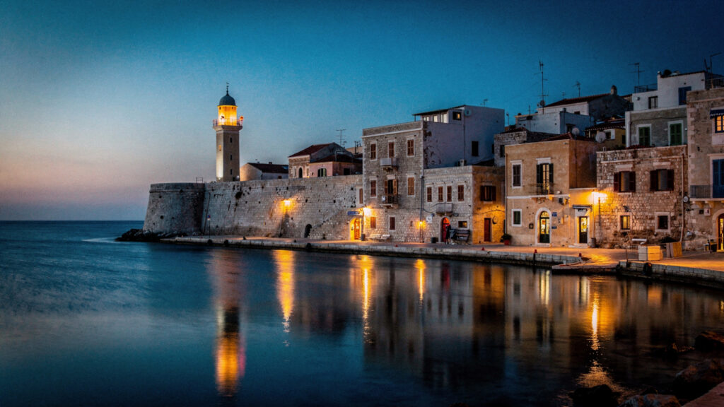
The Venetian harbor is the city’s most recognizable image: the lighthouse at the end of the sea wall, the curve of the harbor front lined with the buildings that Venetian merchants and officials commissioned over four centuries of governance, the water inside the harbor taking the light in the way that enclosed, calm water in a southern climate does. The lighthouse dates in its current form to the early nineteenth century, built on the foundations of a Venetian original, and it marks the outer end of a sea wall that the Venetians constructed to protect a harbor that the island’s geography had made important since the Bronze Age.
The old town behind the harbor is a pedestrian environment of narrow streets built on a scale suited to the pre-motorized city. The buildings reflect the Venetian, Ottoman, and Greek construction styles in layers that the street-level observer can read in the varying details of doorways and upper stories. The mosque of the Janissaries at the harbor front is one of the oldest Ottoman buildings in Crete and is now used as an exhibition space. It serves as the most prominent surviving structure of the Ottoman period in the city. The church of Saint Nicholas was converted to a mosque during the Ottoman period and reconverted to a church after the unification of Crete with Greece in 1913. It still carries both a minaret and a bell tower, each added in its respective period of conversion.
The covered market of Chania was built in the early twentieth century on the plan of a cross. It is the daily economic center of the old town and the place to understand what Cretan food is before encountering it prepared at a restaurant. The olive oil, the cheeses, the herbs, the local honey, the raki in its various forms, and the cuts of Cretan meat that appear in the home kitchen are all present here in their primary form. They exist alongside the conversation of the vendors and the regular customers that constitutes the social life of a working market.

The Samaria Gorge begins its descent from the Omalos plateau, accessible from Chania by bus or hired car, in the early morning when the descent through sixteen kilometers of gorge to the Libyan coast village of Agia Roumeli is typically undertaken. The gorge is the longest in Europe, descending through the rock formations of the White Mountains in a series of passages of varying width, the narrowest section, the Iron Gates, bringing the walls to within a few meters of each other at a height of three hundred meters. The walk is one-directional and requires transportation back from the coast by boat to Sfakia and then bus to Chania. It requires approximately five hours for the average walker at a moderate pace, more if the path is crowded in peak season, and appropriate footwear is the only technical requirement.
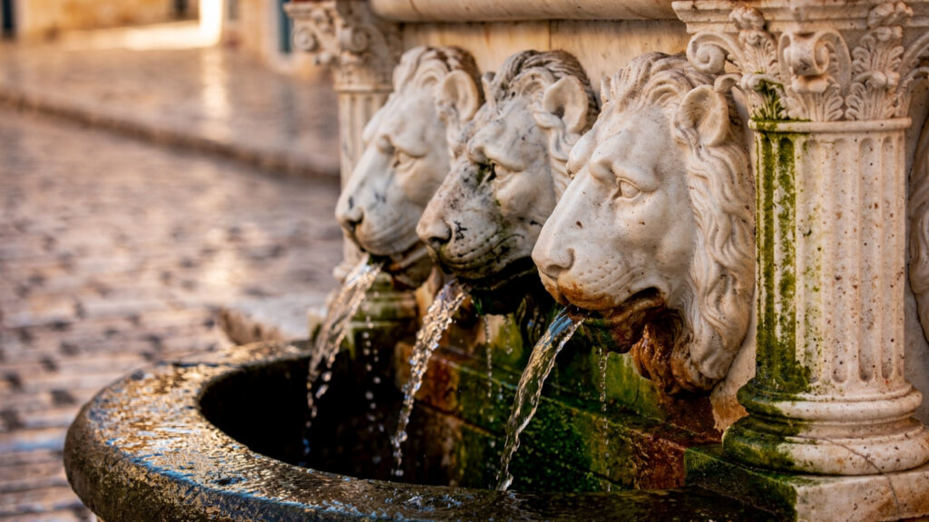
Rethymno and the Fortezza
Rethymno occupies the middle section of the northern coast between Heraklion and Chania and carries the most intact Venetian old town of the three major northern cities, an urban environment of cobbled streets, Venetian-period loggia buildings, minarets converted from church towers, and the great fortezza on the promontory above the harbor that the Venetians built in the sixteenth century in response to Ottoman naval pressure and that the Ottomans took anyway in 1646.
The Fortezza is the largest surviving Venetian fortification in Crete and one of the most substantial in the eastern Mediterranean. Its walls enclose an area large enough that a small city existed within them during the Venetian period, with administrative buildings, a cathedral converted to a mosque after the Ottoman conquest, and the garrison infrastructure of a significant military installation. The mosque within the fortezza, Ibrahim Han Mosque, is the largest surviving Ottoman mosque in Crete and one of the most architecturally significant buildings of the Ottoman period on the island.
The Rimondi Fountain in the town below the fortezza dates to 1629, mid-Venetian period, and marks the center of the old town’s street life in the way that such fountains functioned in Italian cities: as a public amenity, a social gathering point, and a display of the municipal identity of the governing class. The lion heads from which the water flows are a repeated motif of Venetian civic architecture in Crete.
The Rethymno Carnival, held in the weeks before Lent and centered on a parade that has grown to involve tens of thousands of participants and spectators, is the largest carnival celebration in Greece and one of the most significant in the Mediterranean region. It derives from the Venetian carnival tradition that the governing class brought to the island and that the local population maintained with enough enthusiasm across the post-Venetian centuries to have produced what it is now: an event that takes over the streets of the old town for the better part of three weeks and that attracts visitors from across Greece and Europe.
The East and the Minoans in the Landscape
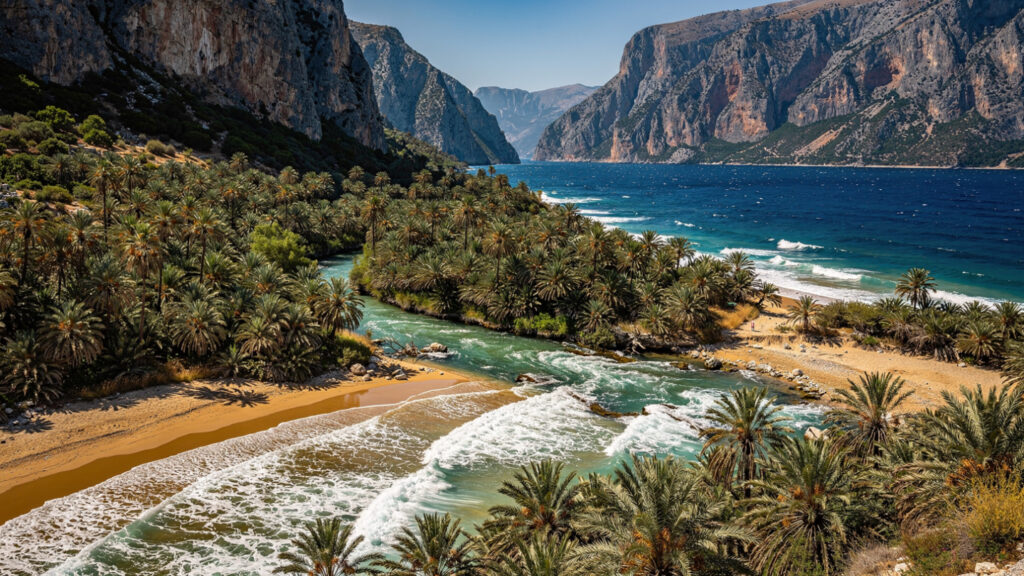
The eastern administrative region of Lasithi contains the sites that make the Minoan dimension of Crete most directly accessible in the landscape rather than in a museum display. These include the plateau communities that maintain agricultural patterns established in the palace period, the cave that the accounts associate with Zeus’s infancy, and the palm beach at Vai. The Phoenix theophrasti grove has been growing there since a date that botanists debate, but most agree it predates the period of intensive human settlement in the region.
The Lassithi Plateau is a high interior plain at approximately 840 meters elevation. It is ringed by the Dikti range and is accessible through mountain passes from the northern coast. It was settled in the Minoan period and has been continuously farmed since. The windmills that gave it its most iconic visual identity were built in the Venetian period to pump water for irrigation. They are now largely preserved as landscape features rather than working structures. The villages of the plateau, with their combination of traditional architecture and agricultural working life, represent the most direct access to the non-tourist Crete that the island’s interior has always contained.
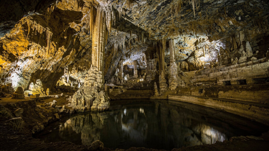
The Dikteon Cave above the village of Psychro is the most visited of the two major caves that the accounts associate with Zeus’s birth or concealment from his father Cronus. The cave is a substantial formation descending through several chambers to a stalactite-filled lower level. Archaeological deposits from the Minoan period through the classical Greek era indicate continuous religious use. The path from the village to the cave entrance takes approximately twenty minutes on foot or is accessible by mule for those who prefer not to walk.
Spinalonga, the small island in the Mirabello Bay accessible by boat from Agios Nikolaos or Elounda, holds a Venetian fortress of the seventeenth century and the remains of the leper colony that occupied the island from 1903 to 1957. The combination of the military history, the medical history, and the physical isolation of the island in a bay of particular beauty has produced one of the most visited sites in eastern Crete. The boat trip from Elounda is fifteen minutes. The site requires at least two hours if the visitor wants to move through it attentively rather than to photograph it.
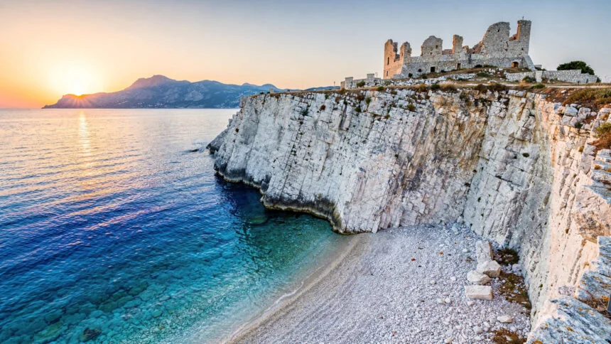
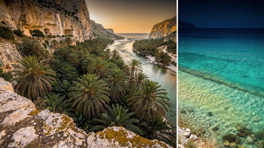
The South Coast and the Libyan Sea
The southern coast of Crete faces the Libyan Sea rather than the Aegean and has a character entirely different from the north. The mountains come closer to the water on the south, leaving less flat coastal land for development, and the road connections to the major northern cities are consistently slower and more winding. The result is a coast that has remained less developed than the north for the same geographic reasons that made it more difficult to access in the first place.
Preveli, in the Rethymno region’s southern reach, is the site of both a monastery and a beach that the Kourtaliótis river reaches after descending through a gorge from the inland mountains. The river crosses the beach and enters the sea between a grove of Cretan date palms that grow where the freshwater meets the salt, and the combination of palm trees, river mouth, gorge, and Libyan Sea is the landscape that gives Preveli its reputation. The beach is accessible by boat from the harbor at Plakias or by a descent from the monastery above, the latter involving approximately forty minutes of walking.
Loutro, the small village accessible only by boat or on foot from the surrounding mountain paths, is the most genuinely isolated settlement on the Cretan coast. It has no road connection to the road network. Its population is small and essentially dependent on the seasonal visitor economy for its economic activity. The quality that this isolation produces in the village, the absence of vehicle noise, the constraint of the settlement to the waterfront and the hillside immediately above it, the quality of being in a place that cannot be reached by accident, is the quality for which people make the effort to reach it.
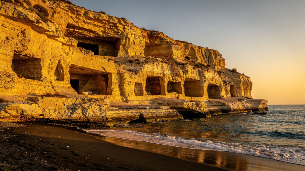
Matala, on the southern coast of the Heraklion region, holds the cave dwellings cut into the sandstone cliffs above the beach that were used as Roman-period tombs and subsequently occupied by a significant population of travelers in the 1960s and early 1970s, a period of the village’s history that the contemporary Matala has partly absorbed into its identity through cafes and souvenirs and partly moved past in the direction of a conventional beach resort.
Food and the Cretan Table
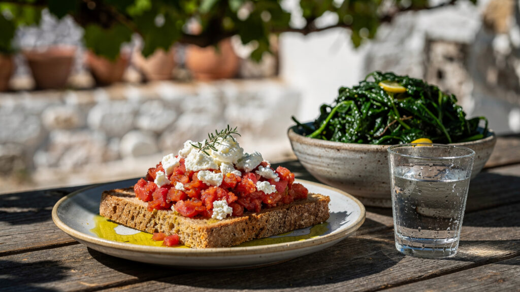
The food of Crete is the most directly connected to the island’s landscape of any Greek regional cuisine, which is the reason that the Cretan diet has attracted the attention of nutritional scientists alongside food enthusiasts: its heavy reliance on olive oil, legumes, wild greens, seasonal vegetables, and moderate amounts of meat and fish reflects the agricultural production of the island rather than the influences of metropolitan gastronomy.
Dakos is the preparation most distinctly Cretan: a dried barley rusk soaked briefly in water or olive oil until partially softened, topped with fresh tomato crushed or grated over the surface, local cheese, and whatever seasonal additions the kitchen offers. It requires ingredients of quality to be worth eating, which is why it is best consumed on the island, from ingredients grown in the island’s soil, rather than attempted from imported components elsewhere.
The wild greens gathered from the Cretan hillsides, the horta that appear on taverna menus throughout the year in the seasonal varieties that the landscape provides, are among the most nutritionally dense elements of the Cretan diet and the most directly connected to the island’s plant ecology. The mountain slopes above the villages of the White Mountains and the Lasithi range produce varieties of edible wild plants that the village women who gather them identify by names that do not appear in any botanical standardization and that reflect knowledge transmitted across generations about what grows where and when.
Tsikoudia, the grape pomace distillate that Crete produces from the residue of its wine pressing, is the island’s most characteristic spirit and the drink with which the Cretan table typically ends: a small glass, cold, often accompanied by a piece of fruit or a sweet, served as the hospitality gesture that marks the completion of a meal rather than as the beginning of an extended drinking session. It is not the same spirit as the raki of the mainland, despite sharing a name in some contexts, and the differences in production method produce a different flavor profile that the Cretan version’s devotees consider superior.
When to Come
Crete operates as a destination across the full year, but the different seasons offer different versions of the island.
April and May bring the wildflowers that the winter rains have made possible: the poppies on the hillsides, the orchids on the mountain meadows, the palette that the island produces before the summer dryness reduces the vegetation to its dry-season colors. The archaeological sites are accessible without the heat that mid-summer brings, and the visitor density is below the July-August peak.
June and September are the best beach months: the water has been warmed by the previous weeks of sun, the crowds are lower than in the peak, and the light in these shoulder months has a quality that the intensity of July and August somewhat reduces.
October brings the olive harvest. The groves on the hillsides above the village communities of the interior produce their crop in October and November. The harvest involves nets laid beneath the trees and the use of hand rakes and mechanical vibrators to loosen the olives from the branches. Visitors who are present in an olive-growing area during the harvest can observe the process. In villages where the local mill is still operating, they can follow the oil from tree to press.
The winter months reduce the island to its resident population and reveal the Crete that exists independently of tourism: the kafeneion conversations, the village squares with their plane trees and their tables of elderly men, the mountain communities whose relationship with the landscape is one of long familiarity rather than seasonal encounter.
At Olympus Estate, Wanderlust Greece guides you across the sacred and storied terrain of the Hellenic world, from the Minoan storerooms of Knossos to the Libyan Sea coast where the gorge reaches the palm grove at Preveli. Crete is not the largest Greek island by accident. It contains everything.


