

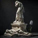

The arm was already gone when she was found.
The Venus de Milo, the marble statue of Aphrodite that a Greek farmer and a French naval officer encountered in a niche in the ancient theater at Tripiti in 1820, was missing both arms at the moment of discovery. The damage predated the excavation. What the two men found was a goddess in two sections, the lower body separated from the upper at the hips, both pieces lying in the collapsed niche of a wall of the ancient Melian theater, alongside a pillar inscribed with the name of the sculptor and a fragment of an arm holding an apple. The arm fragment disappeared in the confusion of the discovery and its immediate political consequences, the maneuvering between Greek and French interests over possession of the statue, and was never recovered with certainty.
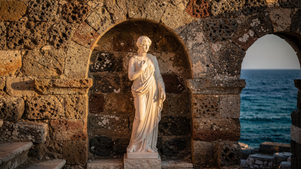
She is in the Louvre now, and has been since 1821. The marble she is made from is Parian, from the quarries on the island of Paros whose stone the ancient world used for the finest sculpture, and the quality of the translucency and grain that Parian marble produces in transmitted light is visible in the Louvre’s gallery in a way that no reproduction can communicate. The island where she was found, Milos, has a full-scale replica in the Archaeological Museum in Plaka, which is not nothing: it gives the visitor to Milos the proportional reality of the statue in the landscape it came from, which is a different encounter than the museum in Paris provides.
But the statue is not why Milos is worth the ferry from Athens or the flight from wherever you are. It is the starting point, the fact that locates Milos in the imagination of anyone who has studied art history, and what the island is, once you arrive, is determined by geology rather than by sculpture.
The Volcano and What It Made
Milos is a volcanic island in the southern Cyclades, 87 nautical miles from Piraeus, and its volcanic origin shapes everything about it in the way that the 1600 BCE eruption shaped Santorini, with the difference that Milos is still geologically active at a level that Santorini’s post-eruption caldera is not.
Mount Syvit, on the island’s eastern side, is one of only two active stratovolcanoes in Greece, a classification that distinguishes it from merely dormant volcanic terrain: the island’s geology is live in the sense that the hydrothermal activity produced by its magmatic system is ongoing, visible in the hot springs that emerge along the coastline, and responsible for the mineral wealth that has made Milos one of the most economically significant geological environments in the Aegean.
The mineral production of Milos is extraordinary by any Mediterranean standard. Obsidian, the volcanic glass that the prehistoric Aegean world used for cutting tools before metal, was traded from Milos to the mainland and the islands across the Aegean from at least 11,000 BCE: the Milos obsidian found at Neolithic and early Bronze Age sites across the eastern Mediterranean is among the clearest evidence of prehistoric maritime trade networks in the region. Bentonite, pumice, perlite, and tuff are all currently mined on the island in quantities that make Milos a significant producer in the European industrial minerals market.
The visual consequence of this geology is the landscape that distinguishes Milos from every other Cycladic island: the colored cliffs, the white lunar formations of Sarakiniko, the cave systems at Kleftiko and Papafragas, the palette of yellows and oranges and reds in the rock faces that the different mineral deposits produce. Milos looks the way it looks because of what is in its rock, and what is in its rock is the product of a volcanic system that has been operating for approximately a million years.
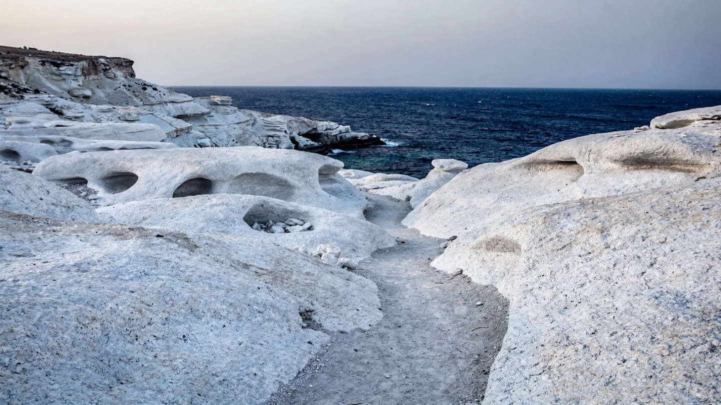
Sarakiniko and the Geological Landscape
Sarakiniko, on the island’s northern coast, is the beach that most directly expresses the Milos geological character in a form that the visitor can walk through and touch.
The white formations that cover the Sarakiniko headland are a type of volcanic ash deposit, compacted and eroded over geological time by the wave action of the Aegean into the rounded, hollowed, smoothed forms that give the site its characteristic quality: a landscape of white curves and hollows that the human eye reads as lunar because it shares with the moon’s photographed surface the combination of white, grey, and black tones without any organic green, and the quality of light that very pale rock in Mediterranean sun produces.
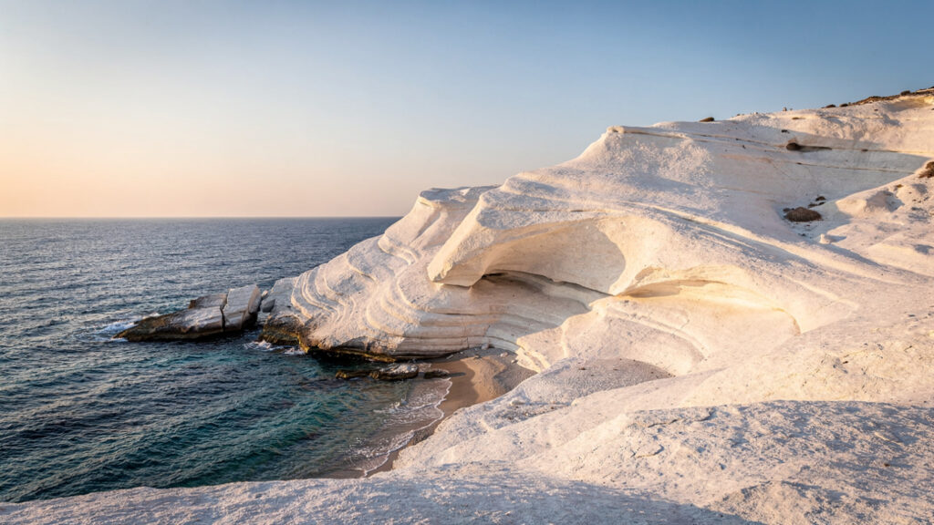
The site is completely open to the sky and to the sea wind, which makes it one of the most exposed positions on the island in summer when the Meltemi blows from the north. The wind that cuts across the Sarakiniko headland is the same wind that shaped the formations, and the visitor who arrives in August at noon will understand, through the combination of reflected heat from the white rock and the direct force of the wind, exactly what the Aegean summer feels like at its most unmediated.
In the morning, before the sun has risen high enough to illuminate the rock at full intensity, and in the late afternoon when the light comes from the west and the shadows in the hollowed formations deepen, Sarakiniko has a quality that the photograph does not prepare the visitor for: quieter, more complex, more geological than the midday version that most of the photographs are taken in.
Kleftiko and the Pirate Coast
Kleftiko, on the island’s southwestern coast, is accessible only by sea, which is the condition that preserved its character through the centuries of tourism development that reorganized the more accessible beaches.
The site is a system of limestone sea caves and arches carved by wave action from the same volcanic rock that produces the island’s visible cliffs, with the quality that sea caves produce in clear Aegean water: the light entering through the cave openings from the surface illuminates the water from below, producing the blue-green luminescence that the Melissani cave in Kefalonia and the Blue Grotto in Capri are famous for but that the Kleftiko formations produce in a more open and more varied form, the light shifting with the movement of the boat and the angle of the sun.
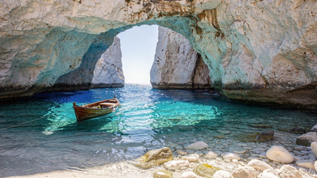
The pirate history is documented: the Ottoman period saw the southwestern Aegean extensively used by corsairs whose knowledge of the cave systems gave them shelter that the Ottoman naval patrols could not easily penetrate. The caves at Kleftiko, accessible only from the sea and deep enough to conceal a small vessel from surface observation, were precisely the kind of shelter that made the southwestern Milos coast useful to anyone who needed to move through the Aegean without being seen. The history is not romantic myth. It is the practical consequence of geography, and the geography is still there.
The boat tours that depart from Adamas to Kleftiko run daily in the summer months, typically combining Kleftiko with the Papafragas sea caves on the northern coast and the beaches accessible only from the water. The journey around the island by sea is the most complete way to understand the coastline’s character: the cliff faces visible from the water, the cave openings that are invisible from the land above, and the palette of the Milos rock face in the different light conditions of the morning and afternoon.
Plaka and the Capital’s View
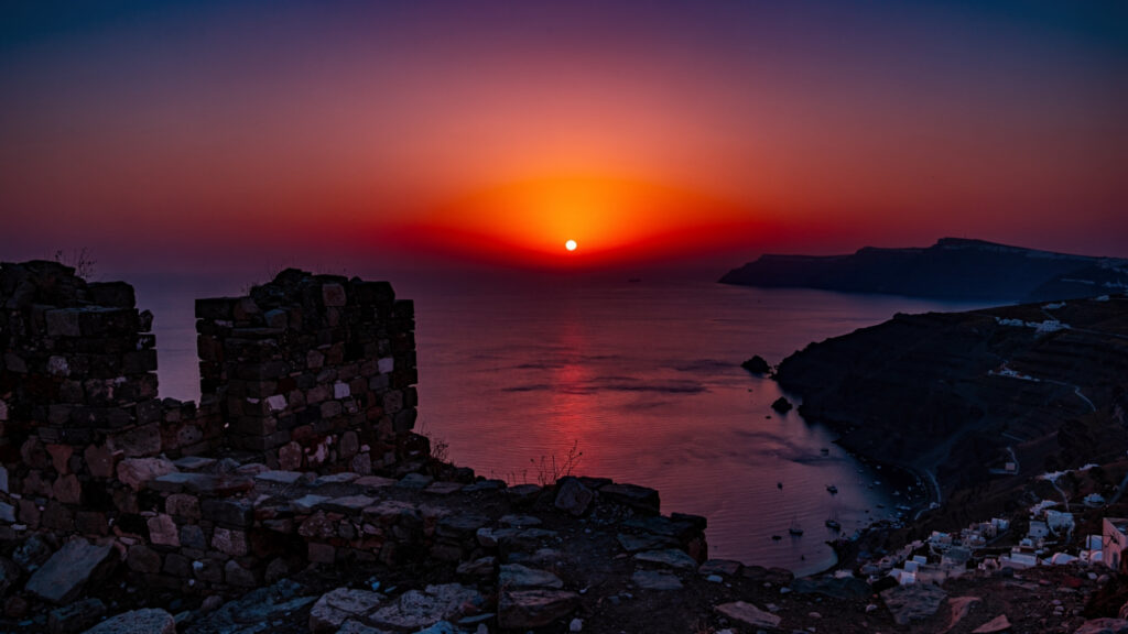
Plaka, the island’s capital, is built on a ridge above the bay of Milos at approximately 200 meters, in the position that the Venetian-era settlement chose for its visibility of approaching vessels and its defensibility from the sea approaches that the Ottoman period made strategically necessary.
The settlement pattern that produced Plaka’s position, a hilltop capital above an accessible bay rather than at the bay level, is characteristic of the Cycladic islands that the Venetian Duchy of Naxos governed from 1207 through the sixteenth century: the Venetian administrative logic placed the population in elevated positions where the approach of hostile vessels was visible and where the population could shelter behind the castle walls when needed. The kasteli at Plaka’s highest point, now in ruins, was the Venetian military installation from which the sea approaches in all directions were monitored.
The view from the kasteli is the most comprehensive single view of the Milos landscape available on foot: the caldera bay below, Adamas and its harbor, the long western arm of the island toward Kleftiko, the geological formations of the northern coast toward Sarakiniko, and on clear days the profiles of the neighboring islands, Kimolos immediately to the northeast and Sifnos further in the same direction. The sunset from this position, which the original article correctly notes as comparable to the Oia sunset at Santorini without the crowd, is the consequence of the view’s orientation: facing west across open water, with no island mass between Plaka and the horizon where the sun descends.
The Archaeological Museum in Plaka holds the island’s material record from the Neolithic period through the Roman era, organized around the themes that the island’s history consistently produces: the obsidian trade, the mineral wealth, the classical period settlement at ancient Melos, and the discovery of the Venus de Milo. The full-scale replica of the statue in the museum’s collection is the best available way to understand the work’s original scale, which the Louvre’s gallery, designed for the conditions of displaying it in Paris, does not communicate in the same visceral terms.
Tripiti, the Catacombs, and Ancient Melos
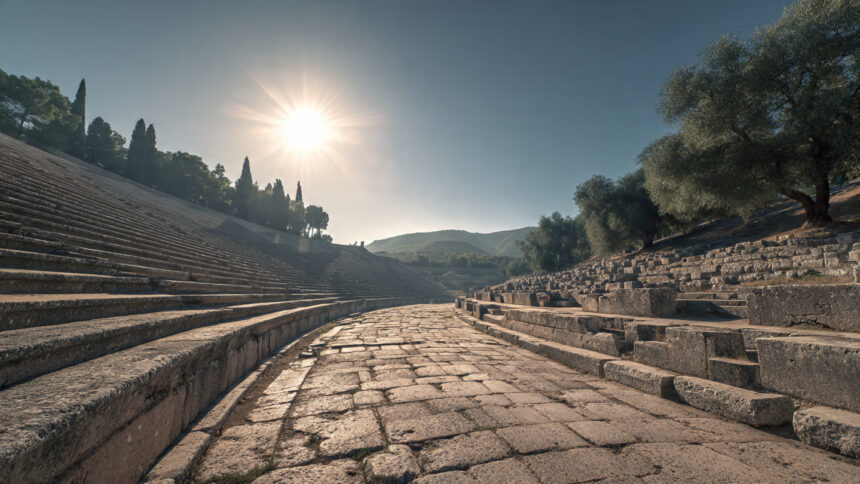
The cluster of sites in and around the village of Tripiti, below Plaka on the southwestern slope of the ridge, constitutes the most concentrated archaeological experience on the island and the one that most directly connects the visible landscape to the documented historical occupation of the site.
The Roman theater at Tripiti, built in the first or second century CE into the hillside below the ancient city, is the site where the Venus de Milo was found in the collapsed wall of a niche. The theater is a small structure by the standards of the ancient theatrical world, capable of accommodating a few hundred spectators in its surviving tiers, but its position on the hillside and the view it commands across the bay of Milos give it a setting that larger theaters in more enclosed landscapes cannot match. The discovery site is marked within the theater’s archaeological precinct.
The ruins of ancient Melos above the theater, the classical Greek city that the Athenians destroyed in 416 BCE and repopulated with Athenian colonists after killing the male population and enslaving the women and children in the event that Thucydides recorded as the Melian Dialogue, the most concentrated examination of power and justice in the ancient historical literature, are fragmentary but significant. Walking the ruins of the city where the Melian Dialogue was conducted, where the citizens who refused Athenian demands were killed, is walking through one of the most precisely documented moral catastrophes in ancient history.
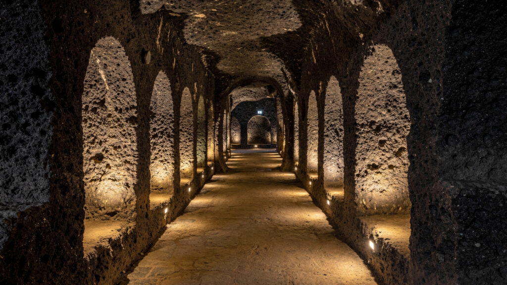
The Catacombs of Milos, a short distance from the theater in the hillside below Tripiti, are the only early Christian burial site of this type in Greece. The tunnels, excavated in the volcanic rock in the third and fourth centuries CE, held approximately 2,000 burials in their original state. The arrangement of the niches in the tunnel walls, designed to hold single bodies wrapped in shrouds, reflects the burial practice of the early Christian community on the island in the period before Christianity became the official religion of the Roman Empire. The catacombs were used for approximately 150 years and then sealed, which is why they survived.
Adamas and the Working Port
Adamas, the island’s main port and commercial center, is the point of arrival for the ferries from Piraeus and the organizational hub for the boat tours, yacht charters, and diving excursions that the island’s coastline makes central to the visitor experience.
The town’s character is that of a working Cycladic port: restaurants and tavernas along the waterfront, the ferry dock at the town’s southern end, the boat tour departure points along the quay, and the atmosphere of a settlement whose daily rhythm is organized around arrivals and departures. The Mining Museum in Adamas is the best available account of the mineral extraction that has been the island’s primary economic activity outside of fishing and agriculture since the ancient obsidian trade: the geological samples, the historical extraction equipment, and the documentation of the minerals that the island produces give the museum a specificity that general island museums lack.
The hot springs accessible from the coastal road south of Adamas, where the hydrothermal activity of the island’s volcanic system produces warm water emerging along the coastline, are the most direct available access to the geological reality that shapes everything else on the island. The water temperature at the primary spring emergence points is warm enough to be immediately perceptible against the Aegean sea temperature, and the mineral content of the water, which gives it a color and a smell distinct from ordinary seawater, is the evidence of the geological system that has been operating beneath the island since before the Neolithic traders came for the obsidian.
The Food of Milos
The Milos culinary tradition is organized around what the island’s combination of geology, climate, and maritime position produces, and the most distinctive elements of it are the products that the volcanic soil and the Cycladic fishing grounds make possible.
The Milos olive, grown in the island’s volcanic soil, has a density and intensity of flavor that distinguishes it from the olives produced on the more calcareous soils of the mainland olive regions. The volcanic soil’s mineral content communicates to the olive in the same way that the volcanic soil of Santorini communicates to the Assyrtiko grape: the mineral character of the terrain is present in the flavor of what grows in it, and the Milos olive eaten on the island, dressed with the island’s own oil and dried oregano, is a different thing from the Milos olive purchased in an Athens supermarket.
The octopus, sun-dried on lines strung between the posts outside the island’s waterfront tavernas in the morning and grilled over charcoal in the evening, is the preparation that most visitors to Milos identify as the definitive local food experience. The sun-drying concentrates the flavor and changes the texture in ways that fresh octopus grilled without drying does not achieve, and the character of octopus grilled this way over charcoal, slightly charred at the tentacle ends and sweet and dense in the body, is the preparation that the waterfront tavernas of Adamas and the fishing villages of Pollonia and Mandrakia produce with the consistency of long practice.

The local fishing tradition that supplies these tavernas works the waters between Milos, Kimolos, and Sifnos, and the fish that the Aegean produces in this part of the southern Cyclades, the sea bream, the sea bass, the red mullet, and the varieties of small fish served as fried meze at the start of a waterfront meal, reflect the ecology of the water the island sits in.
When to Come
The island’s geological and archaeological attractions are available year-round and are best experienced in the shoulder seasons when the access paths are walkable without the summer heat and the sites are uncrowded.
April and May provide the spring conditions that the island’s terrain is most beautiful in: the wild flowers on the volcanic hillsides, the light before it reaches the summer intensity, and the water warm enough for swimming from late May onward. The Sarakiniko formations in the morning light of May are at the farthest remove from the crowded midday summer experience and most clearly express the geological character that produced them.
June through August provides the beach conditions and the full boat tour operation, with the summer Meltemi wind creating the Aegean sailing conditions that the Kleftiko and Papafragas tours depend on for their best water clarity. The wind that makes Sarakiniko uncomfortable at noon in August makes the Kleftiko caves more brilliant at the same hour.
October provides the combination of warm sea water, emptied summer crowds, and the quality of the Cycladic autumn light that makes the mineral colors of the island’s cliffs most saturated and most distinct from the bleached-out palette that the high summer haze produces.
At Olympus Estate, Wanderlust Greece guides you across the sacred and storied terrain of the Hellenic world. The Venus de Milo was found in the collapsed niche of a theater wall in 1820. Both arms were already missing. The statue is in the Louvre. The island is in the southern Cyclades, 87 nautical miles from Piraeus, still geologically active, still producing obsidian and bentonite and pumice from the volcanic system that has been operating beneath it for a million years. The Athenians killed the male population of Melos in 416 BCE and Thucydides recorded it as the Melian Dialogue. The catacombs in the hillside below Tripiti held 2,000 burials and were sealed for 1,600 years. The octopus dries on lines outside the waterfront tavernas in the morning and is grilled over charcoal in the evening. The Sarakiniko formations at dawn look nothing like the midday photographs. Go in May.


