


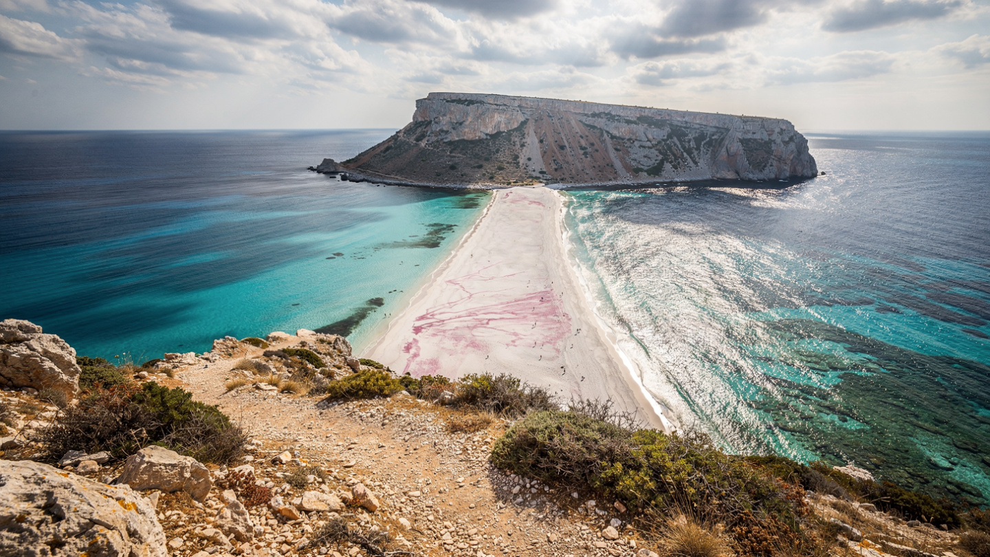
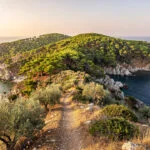
Balos is at the end of everything.
The northwestern tip of Crete, the cape that extends into the meeting point of the Aegean and the Mediterranean, is the edge of the island in the most literal sense: beyond it there is only open water until the North African coast, and the quality of the light and the wind at this extremity of the island reflects the fact that no landmass intervenes between here and there. The lagoon that forms in the shelter of this cape, behind the narrow spit of land that connects it to the island body, is the lagoon that three seas have been working on for as long as the geological feature has existed: the Aegean from the north, the Ionian from the west, the Libyan from the south.
The color of the water is the product of this geography and the geology of the lagoon’s floor: the shallow water over white sand and crushed coral, lit by the direct Mediterranean sun, produces the twenty-or-so distinct shades of blue, green, and turquoise that visitors consistently attempt to photograph and consistently fail to capture in the way the eye sees them directly, because the camera records a single moment of a water color that changes continuously with the movement of the cloud cover, the angle of the sun, and the depth of the water beneath the particular patch of surface the lens is aimed at.
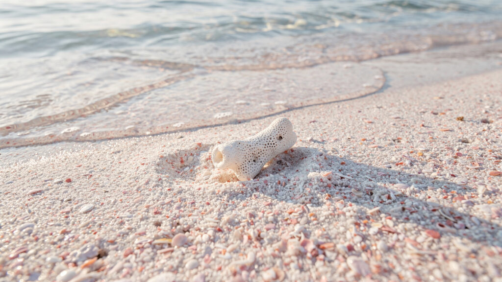
The pink tinge in the sand, which is real and not a tourist board enhancement, comes from the crushed fragments of Pinna nobilis, the fan mussel, and various coral and shell species whose calcium carbonate structures the wave action has ground into powder over geological time. Walking barefoot on the Balos sand in the early morning, before the day visitors arrive, in the quality of the northwestern Cretan light before it reaches its full midday intensity, is the experience that the photographs of Balos are attempting to reproduce. The photographs are consistently inadequate.
How the Lagoon Was Made
The lagoon at Balos is a tombolo: a landform created when wave action deposits sediment between a cape or island and the mainland, eventually connecting them by a sandbar. The tombolo that creates the Balos lagoon connects the rock formation of Cape Tigani, the pig’s head cape whose profile from the sea gives it the name, to the main body of northwestern Crete.
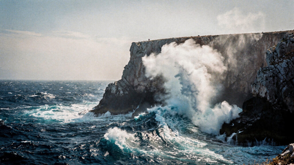
Cape Tigani rises to approximately 120 meters at its highest point, the rocky massif that shelters the lagoon from the prevailing northwesterly winds that the open Aegean generates across the winter and that the summer meltemi continues into the sailing season. This shelter is the reason the lagoon exists in the form it does: without the wind protection that the cape provides, the sediment that forms the sandbar would be dispersed by the wave action that the exposed shore receives.
The island of Imeri Gramvousa, which the daily ferries from Kissamos stop at before proceeding to Balos, is the visible remnant of the larger geological feature that included the cape: a separate rock formation whose separation from the mainland reflects the same geological forces that shaped the cape and the lagoon, and whose summit carries the Venetian fortress whose story runs from its construction in the early sixteenth century through its seizure by Greek independence fighters in the 1820s and its use as a base for their operations against the Ottoman navy.
The water temperature in the Balos lagoon is consistently warmer than the open sea temperature at the same time of year, because the shallow enclosed basin heats more readily than the deep open water: a geological characteristic that makes the lagoon particularly comfortable for swimming from April through November, an extended season that the exposed beaches of the more open Cretan coasts cannot match.
Getting There and What Each Route Provides
The two routes to Balos are not merely different means of reaching the same destination. They are genuinely different experiences of the landscape, and the choice between them shapes what the visit is.
The sea approach, on the daily ferries from Kissamos port that operate from approximately May through October, provides the experience of the lagoon as it appears from the water: the approach from the open sea toward the cape, the gradual revelation of the sheltered water behind it, and the angle from which the beach and the lagoon are first visible that the land route never produces. The stop at Gramvousa on the way out provides the Venetian fortress and the view from the summit that the island’s height makes possible: the Gramvousa channel, the cape, and the lagoon visible simultaneously in the relationship that the sea traveler understands as the geography of this corner of Crete. The ferry from Kissamos takes approximately 90 minutes to reach Gramvousa and a further 30 minutes to Balos.
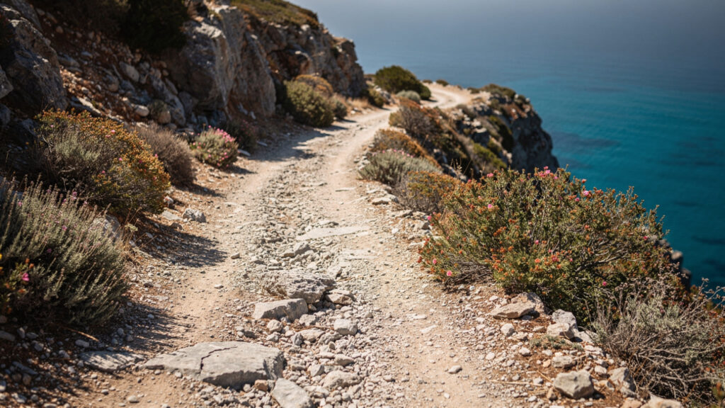
The land route, which begins in the village of Kaliviani approximately 12 kilometers southeast of Kissamos and follows an unpaved track through the rocky scrubland of the cape’s interior, provides the experience of the landscape that the sea route misses: the vegetation of the northwestern tip of Crete, the low phrygana of thyme and sage and rock rose that covers the limestone terrain, the sudden views of the open sea on both sides of the cape as the track approaches the highest point, and the first sight of the lagoon from above, looking down onto it from the parking area at the track’s end rather than approaching from the water.
The unpaved track is genuinely demanding for standard vehicles: 10 kilometers of limestone gravel with sections that have broken through to the bedrock below, on a road that has no barriers between the track surface and the drop to the sea in several of its sections. A vehicle with good ground clearance and road appropriate for unsealed roads handles the track without difficulty. A standard sedan, particularly a loaded one, risks undercarriage damage on the sharper sections. The track is also used by the donkeys and mules that carry the equipment for the Balos facilities up from the parking area to the beach, and by the occasional local farmer who has grazed this terrain for longer than the tourist infrastructure has existed.
From the parking area, the descent to the beach is approximately 1.5 kilometers on a footpath that the land formation makes steep in the first section and gentler as it approaches the beach level. The descent takes approximately 20 minutes. The ascent back to the parking area takes 30 to 40 minutes, considerably more difficult in the late afternoon heat that the limestone reflects back at the walker.
The Beach and Its Facilities
Balos operates within the Natura 2000 European protected area network, and the restrictions that this designation imposes on development are the reason the beach remains in the condition it is rather than in the condition that its visual appeal would otherwise produce under the development pressure that the number of visitors generates in the summer months.
The infrastructure at the beach is deliberately minimal: sunbeds and umbrellas for hire during the operating season, a small café serving basic refreshments near the beach access, and the sanitary facilities that the minimum visitor requirement demands. No beach bars, no water sports rental operations, no restaurant, and no accommodation directly at the beach. The visitors who arrive by ferry from Kissamos typically have four to five hours at the beach before the return departure, which is sufficient for swimming, the walk along the sandbar toward Cape Tigani, and the ascent to the chapel of Agios Nikolaos at the cape’s shoulder.
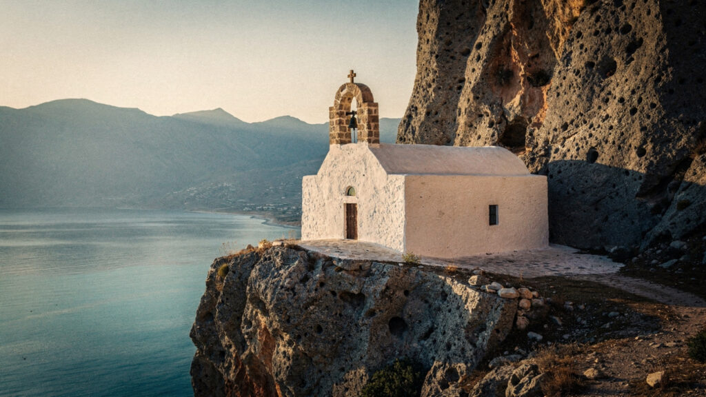
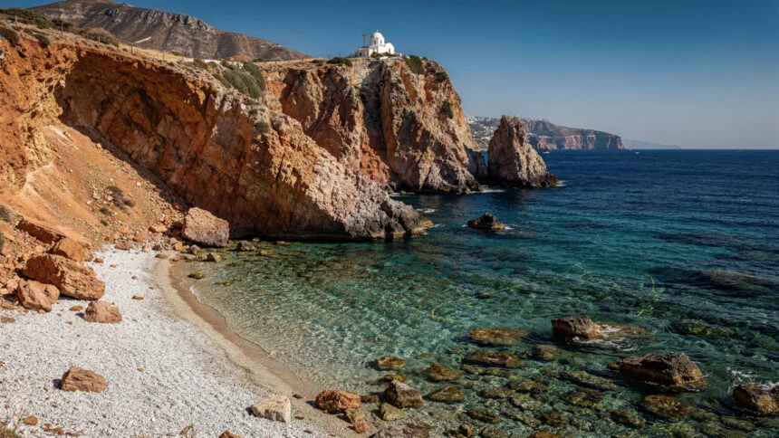
The chapel of Agios Nikolaos, the small whitewashed structure built directly onto the rock face of Cape Tigani approximately halfway between the beach and the cape’s highest point, is the heritage element that the geological and natural character of the site sometimes causes visitors to overlook. The view from the chapel’s position, looking back along the lagoon and the sandbar to the main body of Crete beyond, is the view that most completely conveys the geography of Balos: the tombolo, the two bodies of water it separates, the cape, and the distance to the mountains of western Crete behind.
The beach itself is divided into the lagoon side, the sheltered inner water that the sandbar creates, and the open sea side, the western face of the sandbar exposed to the prevailing westerlies. The lagoon side is the swimming beach: the shallow, warm, calm water that makes Balos accessible to children and to anyone who wants to enter the sea without managing waves or current. The open sea side is the beach that provides the view of the open water toward the island of Gramvousa and beyond it toward the north, and the wind on the exposed side makes it uncomfortable for extended sitting even in conditions that the lagoon side handles comfortably.
When to Come
The Balos question is not whether to come but when, and the answer depends on what version of the experience the visitor is seeking.
The summer peak, July and August, brings the maximum visitor density: the daily ferries from Kissamos carry several hundred people to the beach on the busiest days, the sunbed availability is fully taken by mid-morning, and the quality of the silence and the light that makes Balos extraordinary is present only in the first and last hours of the day. The visitor who arrives on the first ferry and leaves on the last has the early morning and the late afternoon at Balos in conditions that the midday visitor does not experience.
The shoulder seasons, May and June in the spring and September and October in the autumn, are the months when the balance between accessibility and the quality of the experience tilts most favorably. The water temperature in May is warmer than the air temperature on some days, and the sea has not yet reached its August maximum but is comfortable for swimming from mid-May onward. The visitor numbers in these months are a fraction of the August peak, the sunbed situation is manageable, and the quality of the spring or autumn light on the Balos water, different from the flat overhead light of the midsummer noon, produces the color variations in the lagoon that the photographs are attempting to capture.
The winter months, from November through April, bring the closure of the ferry services and the practical inaccessibility of the land route in the weather conditions that the northwestern tip of Crete experiences in the winter: rain, wind, and the Mediterranean combination of cold air and rough sea that the cape’s exposure to the open Atlantic-influenced westerlies produces. The beach in winter is empty and the lagoon is a different color, grey-green rather than turquoise, the sediment disturbed by the winter wave action, the atmosphere entirely different from the summer version. Visitors who have experienced Balos in both seasons consistently report them as two distinct places.
Balos and Western Crete
Balos is not a standalone destination but the most spectacular single point in the corner of Crete that rewards the visitor who treats the whole western peninsula as a landscape rather than as a sequence of attractions.
Kissamos, the market town that serves as the logistical base for the Balos visit, has a small but well-curated archaeological museum whose Hellenistic and Roman mosaics from the ancient city of Kissamos, which occupied the site of the modern town, represent a layer of Cretan history that the Bronze Age focus of most Cretan tourism overlooks. The museum is a 45-minute visit that changes the character of the drive between Chania and the Balos ferry: the Roman mosaic floor of a Kissamos house, depicting the months personified as seasonal figures in the iconographic tradition of the second and third centuries CE, is the evidence that this corner of Crete was a prosperous Roman provincial town before it became a tourist base.
Chania, 50 kilometers east along the northern coast, is the Cretan city that most directly preserves the layering of Venetian, Ottoman, and modern Greek identities that the island’s history produced: the Venetian harbor and its lighthouse, the covered market, the Ottoman mosque now used as an exhibition space, and the character of the old city’s lanes that the twentieth century has modified without entirely rewriting. The Chania Archaeological Museum in the former Venetian church of San Francesco is the appropriate complement to the Heraklion Archaeological Museum for the visitor who wants to understand Minoan western Crete, which the Chania museum’s collections from the sites of Khania, Aptera, and the Minoan harbor city of Nerokouros document.
The Cretan White Mountains, the Lefka Ori, whose highest peak Pachnes reaches 2,453 meters, are the inland backdrop to the entire western Cretan visit: visible from the Balos cape on clear days as the snow-capped massif above the coastal plain, and accessible from Chania through the Samaria Gorge descent to the Libyan Sea coast that the dedicated Crete travel guide in this collection covers. The visitor who combines the Balos lagoon with the Samaria Gorge in the same western Crete visit has experienced the two most spectacular natural features of the western island in the complementary forms they offer: the sea at its most still and the mountain at its most dramatic.
At Olympus Estate, Wanderlust Greece guides you across the sacred and storied terrain of the Hellenic world. Balos is where three seas meet and deposit their sediment into the shade of turquoise that the photographs cannot accurately reproduce. Come in May or September. Arrive on the first ferry or descend the track before the heat builds. The lagoon is the same every day and different every hour.


