


The Colossus is gone and was probably never where people think it was.
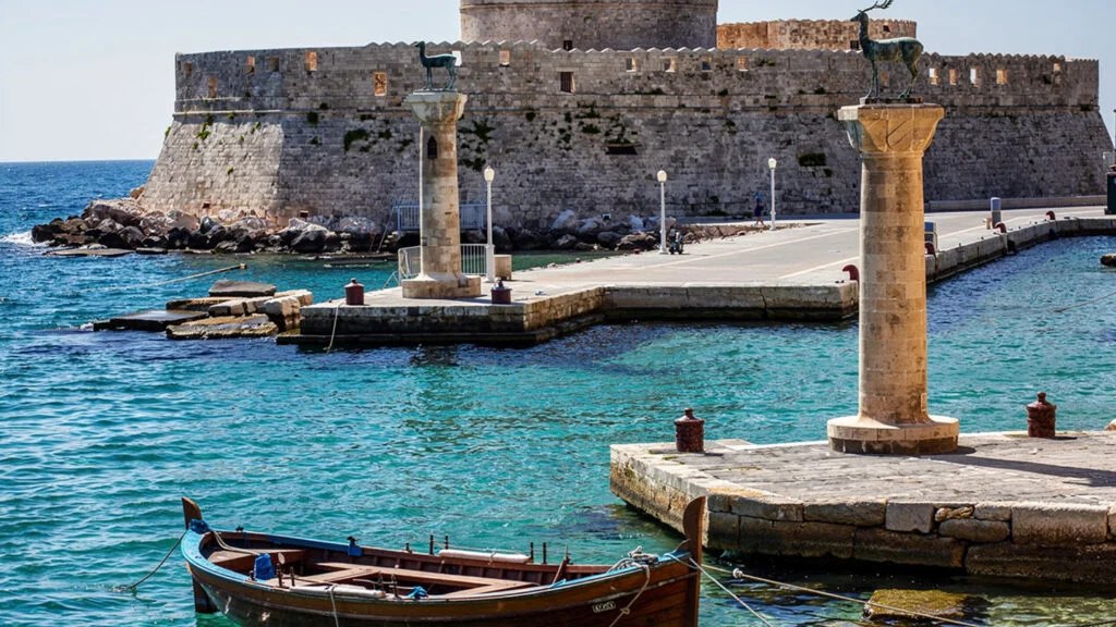
The thirty-meter bronze statue of Helios that the ancient world counted among its Seven Wonders was built at the entrance to the harbor of Rhodes in 292 BCE and destroyed by an earthquake in 226 BCE, approximately fifty-six years after its completion. Ancient sources placed it at the harbor entrance, and the later tradition, following a mistranslation of a medieval text, located it specifically astride the harbor mouth with ships sailing between its legs. This image, which appears in illustrations from the Renaissance onward and which the two columns at the entrance to the Mandraki harbor now supposedly mark, is an invention. The Colossus stood somewhere near the harbor, most likely on land rather than across the water, and fell before most of the ancient world’s writers had the opportunity to describe it directly.
What replaced the Colossus in the history of Rhodes is, in its own way, as remarkable: the medieval city that the Knights Hospitaller built between 1309 and 1522 within the walls they inherited and substantially extended, which is the best-preserved medieval fortified city in Europe and the structure that defines the character of Rhodes Town more than any surviving ancient monument. The ancient city of Rhodes, founded in 408 BCE through the synoikismos, the political merging, of the three earlier city-states of Lindos, Ialyssos, and Kamiros, was among the most prosperous and culturally significant in the Aegean world. What survives from it above ground is fragmentary. What the Knights built is largely intact.
Rhodes is the largest island of the Dodecanese, the southernmost major island group in the Aegean, located at the junction of the Aegean and Mediterranean seas approximately 18 kilometers from the Turkish coast at its closest point. It is 77 kilometers long and 37 kilometers wide at its broadest point, with a population of approximately 115,000 and the specific combination of an ancient, medieval, and modern layer in its cities that the island’s consistent strategic importance over three thousand years of recorded history has produced.
The Medieval City and What It Is
The walled city of Rhodes, designated a UNESCO World Heritage Site in 1988, is the most intact medieval fortified urban environment in Europe, and that designation is not a promotional category but a documentary fact that the physical fabric of the city supports.
The walls themselves, approximately four kilometers in circuit, were built by the Knights Hospitaller over the course of their occupation of the island from 1309 to 1522, reinforced against the evolving artillery technology of the period in a sequence of defensive upgrades that the archaeological investigation of the fortifications has dated and documented. The moat that runs between the outer and inner wall systems was never filled with water in the traditional sense: the Knights used it as a defensive void across which an attacker would have to move under fire from the walls above, and the depth and profile of the moat reflect the specific defensive logic of late medieval military architecture rather than the romantic image of water-filled moats.
The Street of the Knights, the Odos Ippoton that runs from the Palace of the Grand Masters to the hospital that is now the Archaeological Museum, is the most completely preserved medieval street in existence: a continuous sequence of Gothic buildings from the early sixteenth century, each built for the specific national group, the langue, of Knights who occupied it, still standing to their original roofline with their heraldic devices still carved above their doorways. The scale of the street is the scale of a working institutional precinct rather than a grand ceremonial axis: narrow, paved with the same stone as the buildings, built for the practical requirements of the Knights’ administrative and residential life rather than for display.
The Palace of the Grand Masters, at the upper end of the street, was the administrative headquarters of the Knights and the residence of their Grand Master, the most senior official of the Order of the Hospital of Saint John. The building was destroyed by an accidental gunpowder explosion in 1856 and rebuilt substantially by the Italian administration that governed Rhodes from 1912 to 1943, a reconstruction that used the surviving medieval fabric as its basis but added elements that the original did not contain and that the visitor encounters now as a combination of genuine medieval structure and early twentieth-century Italian interpretation of it. The mosaic floors in several of the palace’s rooms are Roman in origin, brought from the island of Kos during the Italian period and installed here rather than in their original location.

The commercial streets of the old city below the Street of the Knights, the Sokratous street that runs through the center of the bazaar quarter, were developed during the Ottoman period after the Turkish conquest of 1522 into the market arrangement that they still broadly follow: a commercial street of small shops and workshops that the tourist economy has reshaped but not entirely replaced. The mosque of Suleiman, built after the conquest to commemorate the Ottoman victory, stands at the upper end of Sokratous street and is the most significant Ottoman architectural monument in the old city.
Lindos and the Acropolis Above the Bay
Lindos is the ancient city of the three that the synoikismos of 408 BCE brought together to form the new city of Rhodes, and it is the one whose ancient monuments have survived in the most coherent and accessible form.
The Acropolis of Lindos occupies the top of a limestone headland that rises approximately 116 meters above the sea on three sides, with the modern village of Lindos below it on the inland side. The climb from the village to the Acropolis, which follows the same route that ancient worshippers used, takes approximately twenty minutes on foot through the stepped alleys of the village. Donkeys are offered as an alternative to the upper section of the path, a tradition whose continuation reflects the practical reality that the Lindos headland was accessed by pack animals throughout the ancient and medieval periods and whose current tourist incarnation is a transaction rather than a continuity, though the donkeys themselves are the same animals the path has always used.
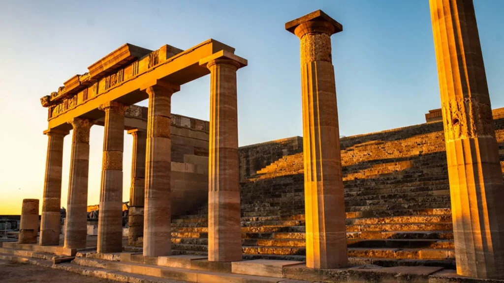
The Temple of Athena Lindia at the top of the Acropolis dates in its surviving form to the fourth century BCE, rebuilt after a fire destroyed an earlier structure, and was active as a religious site into the Byzantine period when it was adapted for Christian use. The Hellenistic stoa that precedes the temple, with its column row still partially standing, and the grand staircase that approaches the propylaia in deliberate architectural reference to the Athenian Acropolis, establish the site’s ambition in its period of maximum investment: Lindos in the fourth and third centuries BCE was wealthy enough from its maritime commerce to rebuild its primary sanctuary in the form that has survived.
The view from the Acropolis is the view that has made Lindos famous in the contemporary travel literature: the great circular bay to the south, the small beach at its eastern end, the village below the headland with its whitewashed cubic architecture, and the sea in the specific blue of the Dodecanese in summer. The view is genuine and as good as its reputation. It is also shared by the significant crowds that the Acropolis of Lindos attracts in July and August, and the visitor who wants to experience the site in conditions that allow sustained looking rather than continuous negotiation of tourist traffic should arrive at opening time, which during peak season means before 8 in the morning.
The village of Lindos itself, car-free by regulation, is one of the most intact examples of Aegean vernacular architecture from the sixteenth and seventeenth centuries, the period when Lindos’s prosperous sea captain class built the houses that now constitute the village’s physical fabric. The decorated stone pebble courtyards, the painted ceilings of the ground-floor rooms, the specific combination of Byzantine, Ottoman, and local Aegean architectural elements in the house facades are the material evidence of the same prosperous maritime economy that built the great Rhodian merchant fleet of the Ottoman period.
Ancient Kamiros and the Archaeological Dimension
The ancient city of Kamiros, on the northwestern coast of Rhodes, is the third of the original city-states that merged to form ancient Rhodes and the one that the contemporary visitor is least likely to encounter, which is the reason to go there.
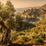
The site occupies a hillside above the sea on the island’s northwestern coast, accessible by a road that passes through the landscape of Rhodian olive and pine that the island’s interior maintains. The ruins are those of a Hellenistic city laid out on a regular grid plan, with the residential quarters on the slopes below and the sanctuary area at the summit of the hill. The site has been excavated since the nineteenth century and the urban plan is readable across the hillside: streets, house foundations, cisterns, the stoa at the top of the hill, and the sanctuary area above it.
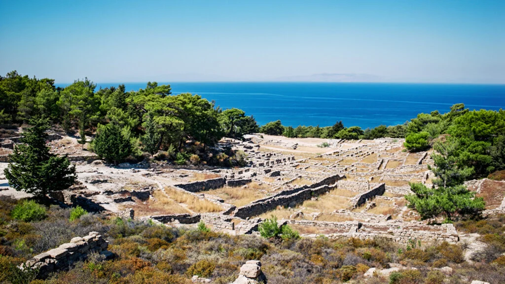
What Kamiros provides that Lindos does not is the experience of an ancient site without the tourist infrastructure that Lindos has accumulated: fewer visitors, no donkeys, a site whose significance is legible from the archaeology rather than from the view. The house foundations on the Kamiros hillside are the foundations of ordinary Hellenistic houses, not a grand sanctuary with theatrical views, and the visitor who walks the grid streets of a three-thousand-year-old city whose residents went about their daily lives in the houses whose floors are still visible under the sky has a different encounter with antiquity than the one that the Lindos Acropolis provides.
The Valley of the Butterflies
The Valley of the Butterflies, Petaloudes in Greek, is a shaded stream valley in the interior of Rhodes whose specific microclimate and vegetation attract large concentrations of Jersey Tiger Moths, Euplagia quadripunctaria, from June through August.
The moths, which are not butterflies despite the site’s name, congregate in the valley to rest and mate during the hottest period of the year. The shade and the humidity that the plane trees and liquidambar trees of the valley produce create the conditions that the moths seek, and they cover the tree trunks and the rocks beside the stream in densities that can reach thousands of individuals per square meter of surface. The moths are motionless when resting and take flight when disturbed, which is why the site’s management requests visitors to move quietly and without creating the disturbances that cause mass flight. The mass flight is visually spectacular and is precisely what the moths are best avoided from experiencing, because the energy expenditure of repeated disturbance-induced flight reduces the moths’ ability to complete their reproductive cycle successfully.

The path through the valley follows the stream for approximately a kilometer and a half, with the moth concentrations most dense in the lower and middle sections of the path. The site is cooler than the surrounding island in summer by several degrees, which makes it an attractive destination independent of the moths on hot August days, and the combination of the shade, the water, and the specific smell of the liquidambar resin that gives the valley some of its insect-attracting character makes it a sensory environment distinct from any other on the island.
Prasonisi and the Southern Coast
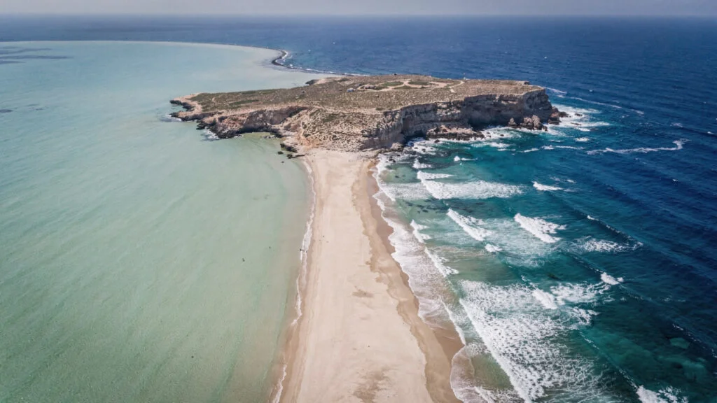
Prasonisi, at the southernmost tip of Rhodes where the island narrows to a point, is the site where the Aegean and Mediterranean seas meet in a way that is visible and physically experienceable rather than simply cartographic.
The sandy isthmus that connects the Prasonisi headland to the main body of the island appears in summer and disappears under the water in winter as the sea level and wave action that governs the beach’s existence varies seasonally. In summer, the isthmus divides the relatively calm Aegean water on its eastern side from the rougher Mediterranean water on its western side, creating conditions where a visitor can stand in shallow water with one hand in each sea, a physical demonstration of a geographic fact that maps represent abstractly.
The wind conditions that the meeting of the two bodies of water produces have made Prasonisi one of the premier wind sport sites in the eastern Mediterranean: kitesurfers and windsurfers use the stronger conditions on the Mediterranean side and the calmer water on the Aegean side for different aspects of their sport, and the beach’s international reputation in these communities draws visitors who come specifically for the wind rather than for the sea.
The road south from Lindos to Prasonisi along the island’s eastern coast passes through a landscape that the tourist development of the northern and central parts of the island has not reached in the same density: the villages of the southern coast, Lachania, Plimiri, Kattavia, maintain the character of agricultural and fishing communities that the Dodecanese maintained before tourism became the island’s primary economic activity. The southern coast beaches, accessible by roads that branch from the main route, are among the least organized on the island.
Rhodes Town, the New Quarter, and the Harbor
The new city of Rhodes, the area outside the medieval walls that developed primarily in the Italian period of occupation from 1912 to 1943 and in the post-war decades, is organized around the Mandraki harbor and the grid of streets that the Italian administration planned and built.
The Italian architectural legacy in Rhodes Town is more significant than the island’s contemporary cultural politics generally acknowledge: the municipal buildings, the market building at the Mandraki harbor entrance, the post office, the courthouse, and the harbor front structures were built in the rationalist and Italianate neoclassical styles that the Italian colonial architecture of the period favored, and they give the new town a visual coherence that distinguishes it from the more ad hoc architectural development of most Greek island capitals.
The Mandraki harbor itself, with the two columns topped by bronze deer that the tourist literature consistently identifies with the position of the Colossus despite the absence of any ancient evidence for this location, is the primary working harbor of Rhodes Town for the smaller vessels, the excursion boats, the private yachts, and the ferry connections to the smaller Dodecanese islands. The commercial ferry port for the major Athens connections is the larger harbor south of the medieval walls.
The nightlife of the new town, concentrated in the bars and clubs of the area around the medieval walls and in the beachfront establishments of the northern coast, operates at a scale proportional to the island’s status as one of the most visited in Greece: multiple venues across the full range of the visitor demographic, from the establishments that attract the extended-stay European summer tourists to the bars of the old town that attract the younger crowd who circulate through the old city’s commercial streets in the evening.
The Food of Rhodes
The Dodecanese culinary tradition that Rhodes represents is the most distinctly influenced by the Ottoman and Middle Eastern food cultures of the region, reflecting the island’s position close to the Turkish coast and the four centuries of Ottoman governance that preceded the Italian period.
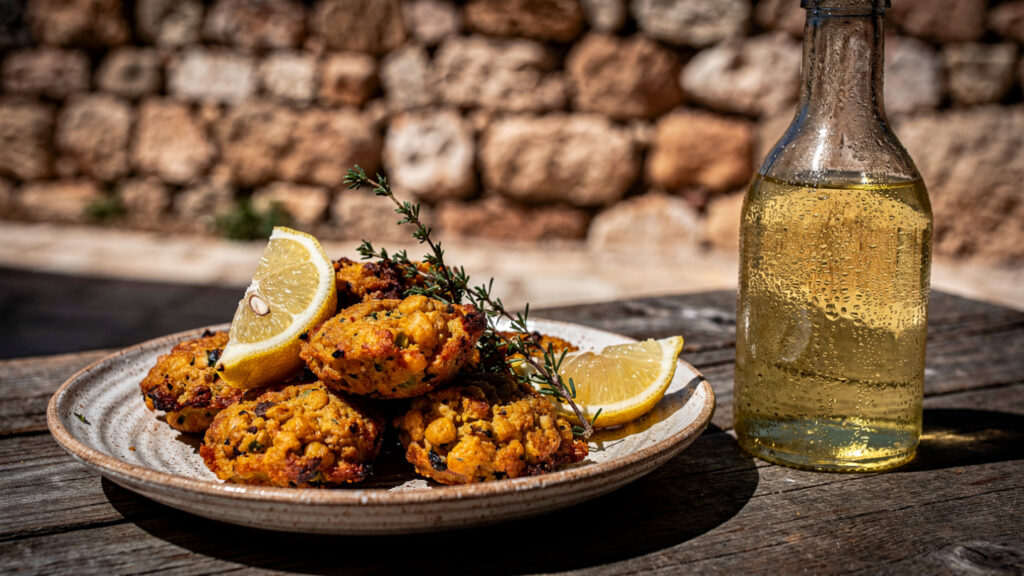
Pitaroudia, the chickpea fritters that are specific to Rhodes, are the island’s most characteristic street food: chickpea flour, onion, herbs, and sometimes tomato formed into small patties and fried, served hot with lemon or yogurt. The preparation is simple and the result depends entirely on the freshness of the oil and the quality of the chickpeas, which are grown on the island in the dryer interior areas. The best version is the one made from the island’s own chickpeas in oil that has not been used too many times.
Macaroni of Rhodes, a pasta dish that the island’s culinary tradition has maintained in a form specific to the Dodecanese, uses a fresh pasta that the cook makes and fries rather than boils, combined with sweet onions and tomato and sometimes meat, in a preparation that reflects the Ottoman culinary tradition’s treatment of pasta as a dish to be cooked through multiple methods rather than boiled and sauced in the Italian manner.
The wine of Rhodes, produced from the Athiri white grape variety that the island’s vineyards have cultivated since antiquity, provides the dry white wine of the local table that the island’s seafood-focused cuisine traditionally accompanies. The Athiri of Rhodes has a specific mineral character that reflects the island’s soil and climate, and the island’s cooperative wine producer, CAIR, makes versions of it across a range of price points, with the older vine versions from the higher altitude vineyards producing the most concentrated expression of what the grape variety achieves in this specific environment.
When to Come
Rhodes operates as a tourist destination for most of the year, with the peak season from late June through August when the island’s capacity is at maximum and the conditions for beach activity are at their best.
May and June provide the spring conditions that the island’s interior is most beautiful in: the wildflowers on the mountain slopes, the lower temperatures that make the archaeological sites comfortable to visit for extended periods, and the visitor numbers at a level below the summer peak. The Valley of the Butterflies in June is at the beginning of its moth season, with lower concentrations than July and August but also lower visitor numbers.
September combines the warm sea water of the summer with the declining visitor density that follows the main European summer holiday period. The beaches are accessible without the organization required in August, the archaeological sites are walkable at midday, and the light that the Dodecanese autumn produces has the specific clarity that the high-summer haze reduces.
The Medieval Rose Festival in late May or early June, when the old city organizes a recreation of its Knights-period atmosphere with events, performances, and the specific visual quality of medieval costume in the medieval streets, provides a reason to visit outside the beach season for those whose primary interest is the city rather than the coast.
October and November bring the conditions that the island’s hikers use: the Mount Ataviros ascent, at 1215 meters the highest point on the island, is most comfortably undertaken in the cooler temperatures of autumn when the summit offers the panoramic view across the Dodecanese and toward the Turkish coast without the summer heat that makes the ascent demanding in July and August.
At Olympus Estate, Wanderlust Greece guides you across the sacred and storied terrain of the Hellenic world, from the Street of the Knights where the best-preserved medieval street in Europe still runs its full length to the Lindos headland where Athena was worshipped before Athens had a name for its own goddess. Rhodes has been at the crossroads of civilizations for three thousand years. The crossroads is still there.


