


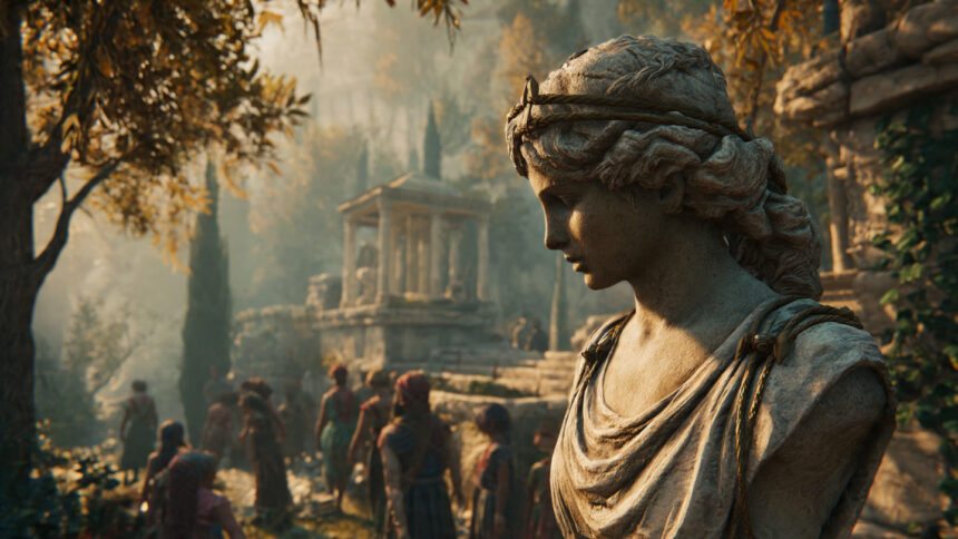
Greece is not only its ruins.
This is the correction that the standard account of the country consistently needs, because the weight of the archaeological and historical heritage is so substantial that it crowds the natural heritage out of the frame. The traveler who comes to Greece for the Parthenon and the Minoan frescoes and the oracle at Delphi is the traveler for whom Greece has been primarily organized as a destination, and the organizing has worked so effectively that the quality of the natural world in which all of this history occurred has become background rather than subject.
The natural world of Greece is one of the most biologically diverse in Europe. Approximately 50,000 animal species have been recorded, among which some 700 are protected. More than 6,000 native plant species grow here, with 900 of them protected. The country’s 236 butterfly species, 50 of which are endemic to Greece and found nowhere else in the world, flutter through wild meadows and mountain pastures whose altitude and microclimate diversity the mainland’s topography produces in a compressed geographic space that few other countries in Europe can match. The loggerhead sea turtle, the Caretta caretta, nests on the beaches of Zakynthos and Kefalonia and the Peloponnese in numbers that make Greece one of the most important nesting sites in the Mediterranean. The Mediterranean monk seal, one of the most endangered marine mammals on earth with a population estimated at fewer than 800 individuals, maintains its last significant populations in Greek waters, particularly around the Ionian Islands and the Northern Sporades.
The biological richness is not incidental to the cultural richness. It is inseparable from it. The landscape of Greece, the limestone mountains, the karstic springs, the Aegean islands scattered across a shallow sea, the wetlands where rivers meet the coast, the altitude range from sea level to the 2,917 meters of Olympus, produced both the human civilization and the biological diversity that coexist within it, and the traveler who engages with only one has understood half.
The Zagorochoria and the Pindus Mountains
Northwestern Greece, the region that the ancient and modern world knows as Epirus, is the part of the country least known to international tourism and the part that repays the engaged visitor most completely with what is genuinely undiscovered.
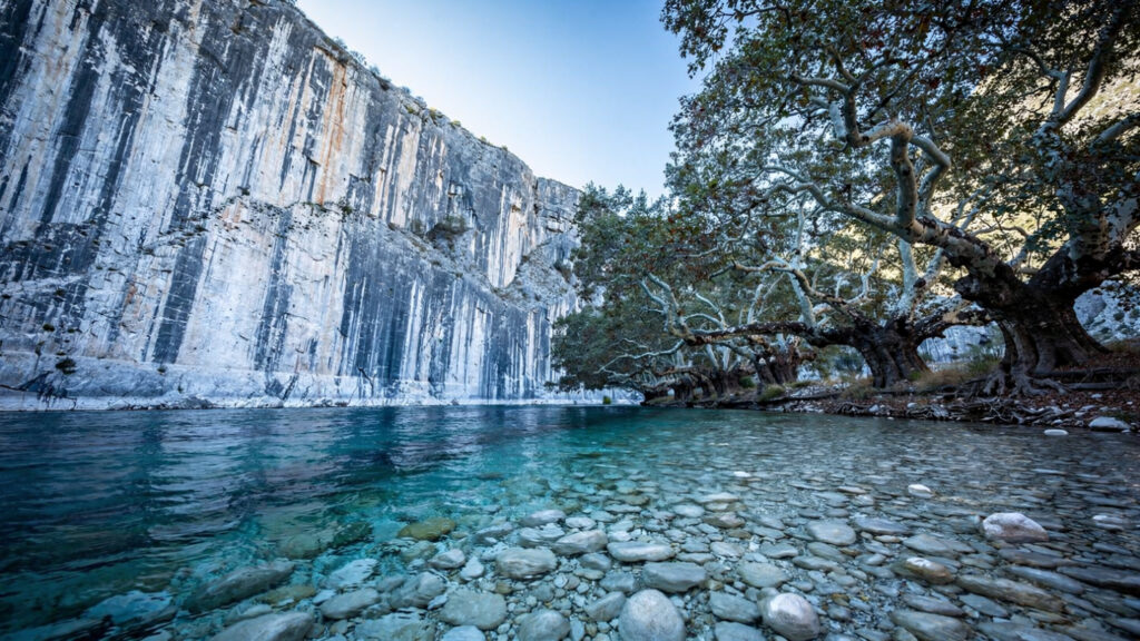
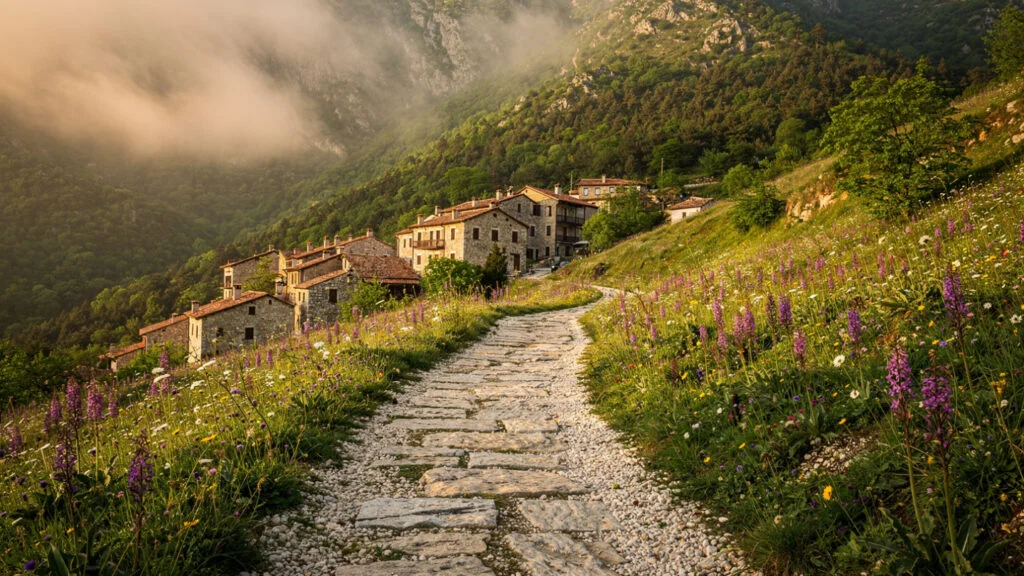
The Zagorochoria, the forty-six traditional villages of the Zagori district in the Pindus Mountains, constitute one of the most completely preserved pre-modern landscapes in Greece: a landscape of Ottoman-era stone houses with slate roofs, churches whose sixteenth and seventeenth century frescoes are in better condition than many urban church interiors, and the network of kalderimia, the cobbled Ottoman-era paths and arched stone bridges, that connected the villages to each other and to the lowlands before the motor road arrived and made the paths unnecessary for transport while preserving them for walking.
The Vikos Gorge, which the Guinness World Records has recognised as the world’s deepest gorge relative to its width, cuts through the Zagori district from the village of Monodendri to the confluence of the Voidomatis River below, a descent of approximately 900 meters through limestone walls whose white faces rise directly above the path in the gorge’s most enclosed sections. The Voidomatis River at the gorge’s base is one of the clearest rivers in Europe: the water that emerges from the karstic springs of the Vikos canyon floor is filtered through the limestone of the Pindus massif until it reaches a clarity that makes the riverbed visible at depths that would be opaque in most European rivers, and the combination of the white limestone, the blue-green water, and the plane trees that line the river’s banks is the visual character of the Zagori landscape at its most concentrated.
The brown bear population of the Pindus, estimated at approximately 450 individuals and constituting one of the largest bear populations in Europe outside Russia, inhabits the forests of the Vikos-Aoos National Park and the surrounding mountain territory. The bears are not easily seen, which is the nature of large mammals in dense forest, but their presence is documented in the track evidence on the forest paths and in the occasional dawn or dusk sighting from the remote village roads. The wolves of the Pindus, whose recolonization of the mountains in recent decades has been one of the most significant wildlife recovery stories in the Balkans, follow the deer and the livestock that the mountain terrain supports, and their presence has changed the ecological dynamics of the forest in ways that the rewilding literature has documented as the trophic cascade that large predators produce.
The Prespa Lakes
The Prespa Lakes, on the northwestern edge of Greece where the Greek, Albanian, and North Macedonian borders converge, are among the most ecologically significant wetlands in Europe and among the least visited by travelers who have not specifically come for the birds.
There are two Prespa Lakes: Megali Prespa, the larger of the two and shared between all three countries, and Mikri Prespa, almost entirely within Greek territory and the more biologically significant of the two for the breeding bird populations that use it. The combination of shallow water, emergent aquatic vegetation, and the microclimate produced by the mountains that surround the lake basin on all sides creates the conditions that the Dalmatian pelican requires for successful breeding, and the Mikri Prespa colony is among the most important breeding populations of this species in the world. The Dalmatian pelican, distinguished from the white pelican by the curly feathers of its head and the steel-grey quality of its plumage in breeding condition, is the largest freshwater bird in Europe, and watching a colony of them in the reed beds of Mikri Prespa is one of the most extraordinary wildlife experiences that the European continent provides.
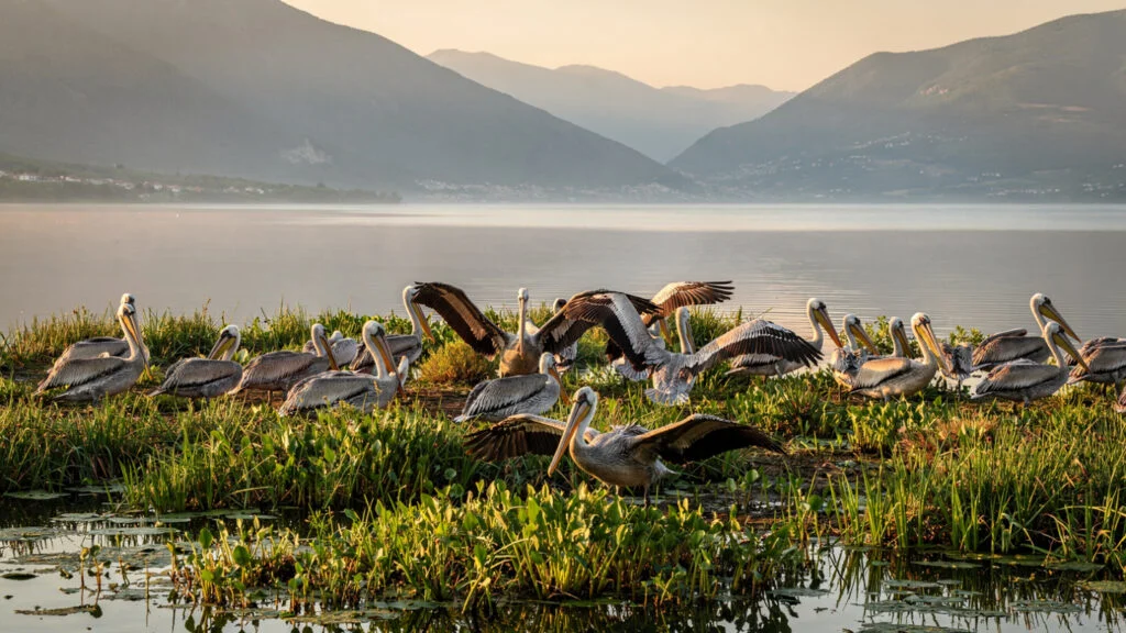
The other breeding species of Mikri Prespa include the great white pelican, multiple heron species, the pygmy cormorant, the ferruginous duck, and a range of wading birds whose nesting requirements the shallow water and the reed beds meet simultaneously. The spring migration through the lake basin, when the Eurasian species returning from their African wintering grounds follow the valley corridors through the mountains, adds the migrant diversity to the resident breeding populations in the weeks between March and May when the lake is at its most productive for the observer.
The villages of the Greek Prespa, the communities that have maintained their agricultural and fishing practices in this landscape for generations, are the human dimension of the Prespa experience that the bird-focused account can overlook. The cuisine that the lakeside communities have developed around the local fish species, the kourounes and the grizadia and the local carp preparations, is the cuisine of a community that has eaten what the lake provides for as long as the community has existed, and the flavors of lake fish prepared in the way the Prespa villages prepare them is the taste of this place.
The Messolonghi Lagoon
The Messolonghi-Aetoliko Lagoon, where the Achelous River and the smaller rivers of central Greece meet the Ionian Sea on the western coast of the mainland, is the largest lagoon in Greece and one of the largest coastal wetland systems in the Mediterranean.
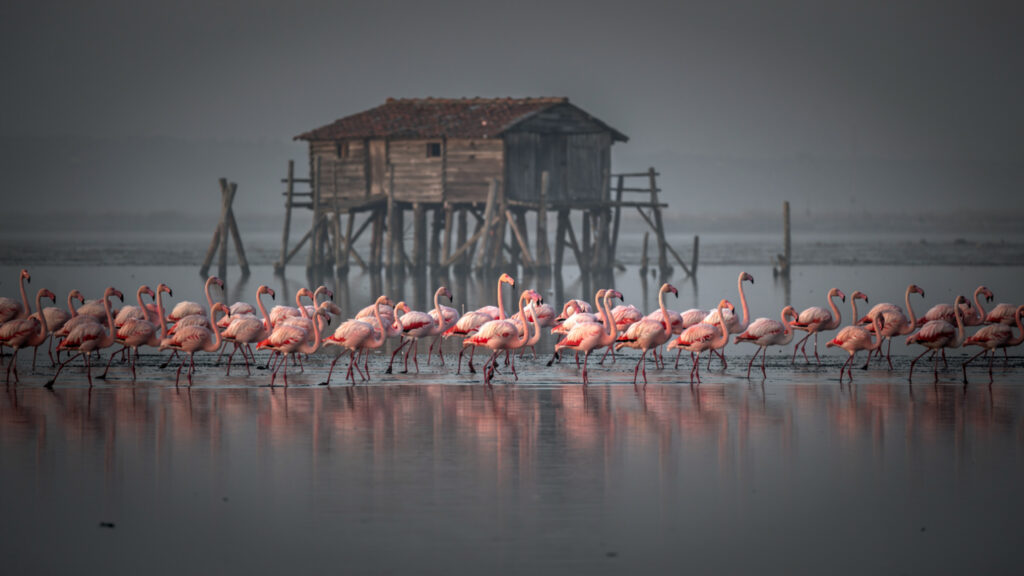
The lagoon’s ecological value is its position as a wintering and migration staging site for the waterbirds of the eastern Mediterranean flyway: the flamingos that the article’s original text mentions are real, feeding in the shallower sections of the lagoon in the winter months in flocks that the combination of the lagoon’s invertebrate richness and its shallow depth makes unusually productive feeding grounds for. The greater flamingo’s improbable pink in the grey winter landscape of the lagoon, its feeding posture of the inverted head and the sieving motion that extracts the brine shrimp and algae from the saline water, is the wildlife image of the Messolonghi that no photograph adequately prepares the visitor for.
The stilt houses built by lagoon fishermen on wooden platforms in the shallow water, known as the pelades, are the human monuments of Messolonghi that the archaeological and historical monuments of more famous sites often exclude from standard itineraries. The oldest surviving examples date to the nineteenth century. They were built on a deep understanding of where fish move through the lagoon channels at different seasons. Builders utilized traditional fishing techniques that the ecology and hydrography of the lagoon made productive for generations. The practice of lagoon fishing in Messolonghi, with its specific net types and seasonal rhythms organized around the movements of fish through the water system, remains one of the most directly traditional food production systems still operating in Greece.
The island of Aetoliko, connected to the mainland by two causeways and sitting within the lagoon as a separate urban settlement with its own character, is among the most unusual communities in Greece: a town built on the water rather than beside it, whose relationship with the lagoon that surrounds it is the relationship of a community that has organized its entire existence around a ecological condition. The evening light on the Aetoliko lagoon, when the flamingos are moving across the shallow water and the stilt houses are reflected in it and the quality of the western sky over the Ionian is present in the distance, is one of the most complete available images of the Greek natural world in its most undisturbed form.
The Sporades and the Monk Seal
The National Marine Park of the Northern Sporades, established in 1992 and encompassing the islands of Alonissos, Peristera, Kyra Panagia, Gioura, and Piperi and the sea between them, is the largest marine protected area in the European Union and the primary stronghold of the Mediterranean monk seal in Greek waters.
The monk seal, Monachus monachus, is the most endangered marine mammal in European waters and one of the most endangered seals in the world: the global population, distributed across fragments of suitable habitat from the Canary Islands to the Black Sea, is estimated at fewer than 800 individuals, with the Greek population constituting the single most significant concentration. The seal’s requirements, the underwater cave entrances that allow access to the internal beaches where the pups are born and which protect the birthing site from both predators and human disturbance, are requirements that the limestone coastlines of the Northern Sporades islands provide in greater concentration than most other available habitat.
Seeing a monk seal in its natural environment is an experience that most people who specifically seek it do not achieve: the animals are wary of boats and the underwater caves that are their primary resting and breeding sites are not accessible to divers or snorkelers without the protective legislation’s permissions. What visitors to the Northern Sporades Marine Park encounter instead is the landscape that the monk seal requires: the limestone sea caves accessible only from the water, the transparent blue-green Aegean over the submerged meadows of Posidonia oceanica seagrass that constitute the primary productive zone of the shallow northern Aegean, and the quality of the marine environment in an area where the protective designation has maintained the water quality and the fish populations at the level that the seal’s feeding requirements demand.
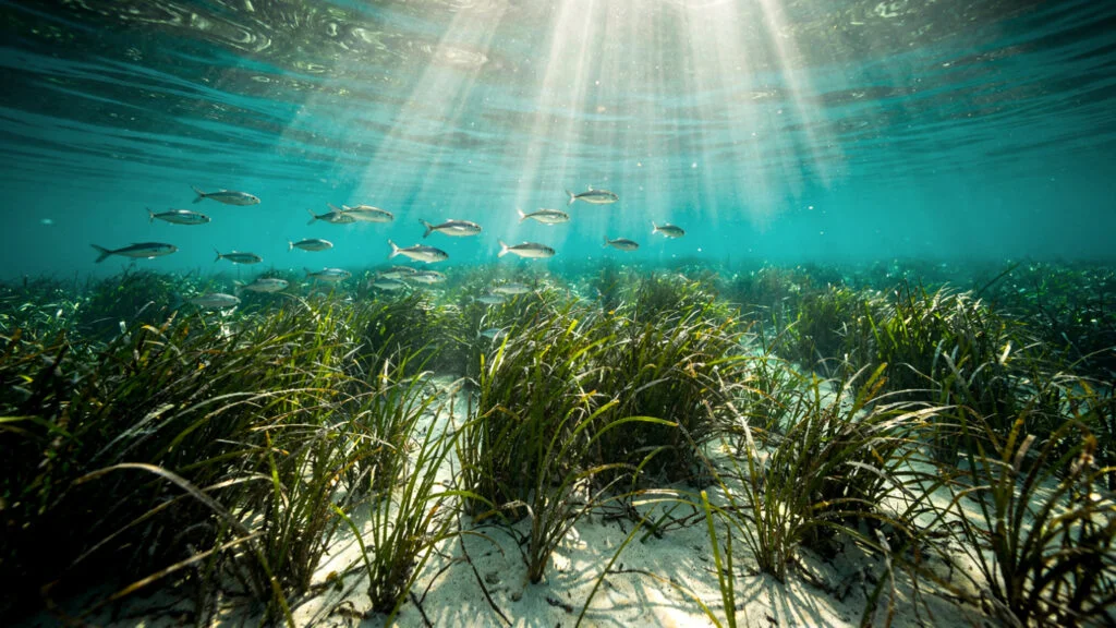
The Posidonia meadows are themselves the ecological foundation of the marine park’s productivity: the seagrass beds that cover the shallow sea floor of the northern Sporades provide the nursery habitat that the fish populations require and the carbon sequestration function that makes the Mediterranean seagrass meadows among the most ecologically significant marine habitats in the global ocean. The combination of the clear water, the sunlight penetrating to the seagrass at depth, and the fish community that the Posidonia meadows support is the marine equivalent of the alpine meadow in its diversity and its beauty.
The Cave Systems
The limestone geology that makes the Greek landscape what it is, the white rock of the Pindus, the Taygetos, the Dikti range in Crete, the Kefalonian mountains, produces the karstic cave systems that the rainwater has excavated over geological time through the process of carbonic acid dissolution: the rain absorbs carbon dioxide from the atmosphere, becomes mildly acidic, and slowly dissolves the calcium carbonate of the limestone through which it percolates, enlarging the cracks and joints until they become passages and the passages become chambers.
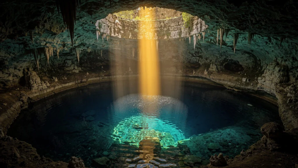
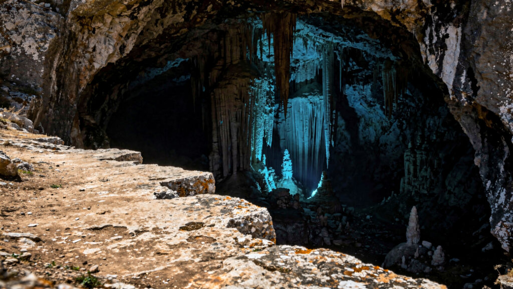
The Melissani Cave on Kefalonia is the most visually spectacular of the accessible Greek caves: the roof of the chamber collapsed some time in antiquity, creating the condition that produces the cave’s famous quality of light. The circular opening above the underground lake allows direct sunlight to enter the cave during the midday hours and illuminate the water from above, producing the effect of the light moving through the clear water, reflecting off the cave floor below and the stalactites above, and changing in character as the sun moves across the sky. The blue-green of the lake water, lit from above by the Mediterranean sun, is a color that the cave produces and that the open water cannot replicate.
The Dikteon Cave on Crete, connected by myth to the birth of Zeus, occupies the most significant landscape position. This cavern opens from the side of the Lasithi plateau. This high inland plain of eastern Crete was utilized and marked by the Minoan, Mycenaean, Byzantine, Venetian, and Ottoman eras in their own ways. The descent into the cave from the edge of the plateau represents a transition from the historically documented human landscape into the geological time defined by the cave formations. The stalactite formations in the Dikteon Cave have been growing at the rate of approximately one cubic centimeter per century. This means the largest formations began growing before the Minoan civilization built Knossos.
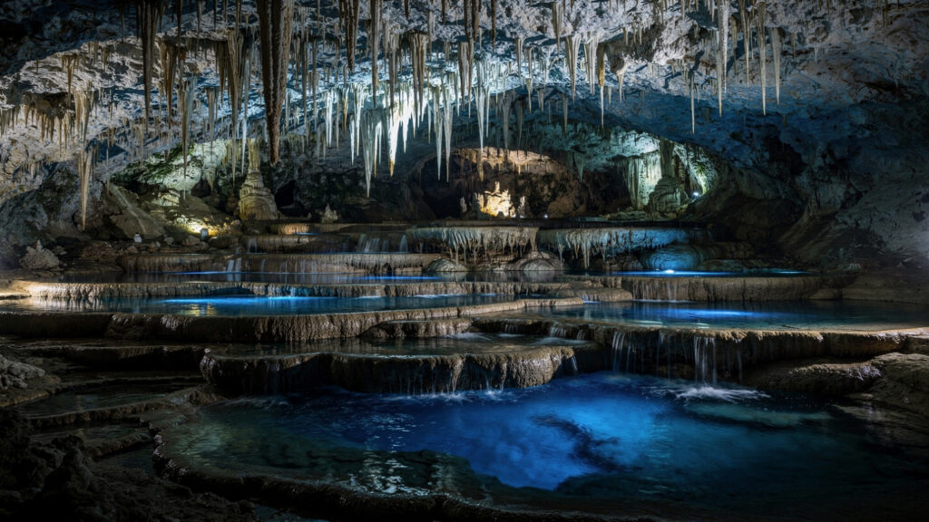
The Cave of the Lakes in the Peloponnese, near Kastria in the highlands of Achaea, is the cave that most directly demonstrates the relationship between the karst cave system and the surface hydrology that the same limestone geology produces: the cave contains twelve terraced lakes separated by natural travertine dams, the lakes formed by the same calcium carbonate precipitation that builds the stalactites above. The visual quality of the tiered lakes, each at a slightly different level, connected by the water that spills over each dam into the one below, is the quality of a system whose logic is entirely geological and entirely beautiful.
Ikaria and the Living Landscape
Ikaria, the Aegean island named for Icarus of the myth, who fell into the sea nearby after his wax wings melted in the sun, is the Greek island that the longevity research has made internationally known for reasons that the island itself treats with considerable equanimity: the combination of the traditional Ikarian diet, the daily physical activity that the island’s steep terrain requires, the culture of afternoon sleep and evening social gathering, and the herb teas, mountain thyme and wild sage and rockrose, that the Ikarian landscape provides in abundance and that the island’s older inhabitants have consumed throughout their lives, has produced a population with one of the highest proportions of residents over 90 in the world.
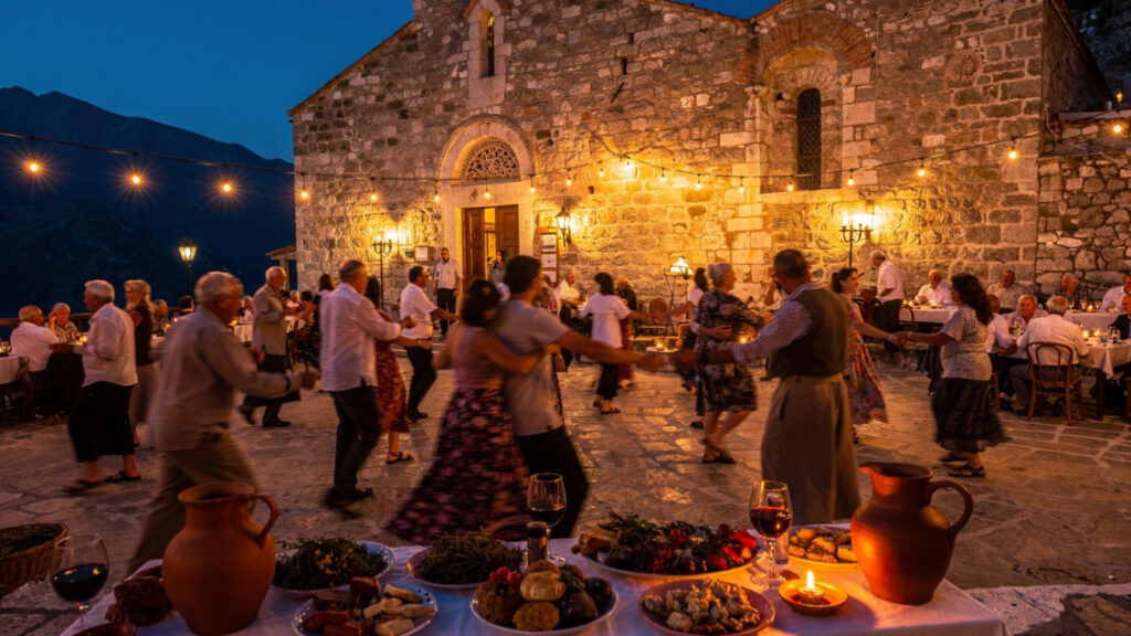
The longevity data is real and the lifestyle associations are documented, but the traveler who comes to Ikaria for the longevity should come for the island itself and allow the longevity associations to be the context rather than the purpose: the quality of the panegyri, the all-night village festival that Ikaria celebrates through the summer months, in which several hundred people gather in a mountain village square to eat and drink and dance from sunset to dawn, is the social practice that the researchers identify as central to the longevity pattern but that the participant experiences as the most vivid available expression of what Greek village life was and in Ikaria still is.
The Ikarian landscape, the dense forest of the island’s interior that the rain-bearing winds from the north maintain in a condition of relative humidity unusual in the Aegean, the quality of the mountain springs that emerge from the island’s volcanic rock, and the wild herbs and the chestnut forests that the altitude and the moisture produce, is the landscape that supports both the traditional cuisine and the microclimate that the longevity researchers identify as one of the contributing factors. Walking the paths from the mountain villages toward the north coast, through the chestnut forest and the flowering heath above the Aegean visible at the paths’ ends, is the Ikarian experience that the panegyri and the longevity statistics do not fully convey: the quality of a landscape that has not been simplified by the tourism economy into a product.
The Menalon Trail and the Peloponnese Highlands
The Menalon Trail, a signed walking route of approximately 75 kilometers through the highlands of the central Peloponnese in the district of Arcadia, is the Greek long-distance walking route that most directly connects the human landscape of the mountain villages to the natural landscape of the forested highlands that surround them.
Arcadia, which the European pastoral tradition used for two millennia as its image of the innocent and uncorrupted natural world, the landscape of shepherds and nymphs and the god Pan, was always a real place before it became a literary convention: the high, cold, forested plateau of the central Peloponnese, isolated by the surrounding mountain ranges from the coast and its commercial centers, where the pastoral economy of sheep and goat herding and the village craft traditions of the Arcadian towns maintained themselves through the classical period and the Byzantine period and the Ottoman period and into the modern era.
The Menalon Trail passes through this landscape at the human scale of walking: the villages of Dimitsana and Stemnitsa and Vytina and the smaller settlements between them, each with its architectural character and its culinary tradition and its relationship to the landscape that surrounds it. The water mills of the Lousios River gorge, where the river has cut through the limestone to create the narrow canyon that the monks of the twelfth-century monasteries built their buildings into the cliff faces above, are the human monuments of the Arcadian landscape that the trail makes accessible to the walker who has time to descend to the gorge floor and follow the river path.
The wildflowers of the Arcadian highlands in May, when the altitude delays the spring enough to produce the combination of the late-season bulbs and the early-season orchids simultaneously, are the botanical expression of the same microclimate diversity that the landscape article has been describing: the rare orchid species of the Peloponnese, the endemic to the southern mainland, grow in the combination of the alkaline soil and the moist spring conditions that the Arcadian highlands produce in the weeks between the snowmelt and the summer dryness.
At Olympus Estate, Wanderlust Greece guides you across the sacred and storied terrain of the Hellenic world. Greece is not only its ruins. The Vikos Gorge and the Prespa pelicans and the monk seal caves and the Ikarian panegyri are the living landscape that the ruins emerged from and that continues to exist around and between and beneath them. The natural heritage of Greece is inseparable from its cultural heritage because both grew from the same land. Go to both.


