

The mountains of the Agrafa were never registered.
This is where the name comes from. Agrafa means the unwritten or the unregistered, and the historical event that produced the name was the failure of the Ottoman administrative system to extend its registration of population and property to the mountain communities of the central Greek mainland. The Ottoman tahrir, the cadastral census and land registration that the administration used to establish the tax base and the population count across its territories, was the instrument of administrative control whose reach determined which communities were inside the system and which were outside it. The Agrafa mountains were outside it. The terrain was too steep, the paths too difficult, the communities too dispersed across the high ridges and the deep ravines for the Ottoman tax officials to reach them on the schedules that the administrative system required. The mountains were unregistered. They remained unregistered through the centuries of Ottoman administration. They kept the name.
The consequence of being unregistered was a form of practical autonomy that the accessible lowland communities did not have: the communities that the Ottoman administration could not reach with its census-takers could not be taxed at the rates the administration was extracting from the registered population, could not be conscripted into the forced labor arrangements that the administration imposed on the registered communities, and could not be administered through the mechanisms of control that depended on the knowledge of who lived where and what they owned. The Agrafa villages maintained their traditional social organization, their religious practices, their economic arrangements, and their cultural identity through the Ottoman period in a form that the more accessible regions of Greece were not able to preserve with the same completeness.
This is what Argithea actually is, before it is anything else: the heart of the unregistered mountains, the capital of the ancient kingdom of Athamania, the region that the inaccessibility of its terrain has preserved in the closest available approximation to the older Greece that the Ottoman administration and the subsequent modernization processes have modified elsewhere.
Ancient Athamania
Argithea was the capital of Athamania, the ancient tribal kingdom that occupied the mountainous interior of the region between Thessaly and Epirus, and the history of the Athamanian kingdom is the history of a mountainous people who maintained their independence through the Hellenistic period by the combination of the defensive advantages of their terrain and the diplomatic skill of managing the larger powers that surrounded them without being absorbed by any of them.
The Athamanians appear in the ancient sources primarily in the accounts of the second century BCE, the period when the geopolitical landscape of the Greek world was being reorganized by the growing Roman power’s involvement in the eastern Mediterranean. The Athamanian king Amynander, who ruled through the critical decades of the 190s and 180s BCE, was a figure of considerable political intelligence who understood the options available to a small mountain kingdom in the period when the large Hellenistic kingdoms of Macedon and the Seleucid empire were being challenged by Rome’s eastward expansion.
Amynander initially allied with Rome against Philip V of Macedon in the Second Macedonian War, the conflict that ended with the Roman victory at Cynoscephalae in 197 BCE and the declaration of Greek freedom by Titus Quinctius Flamininus at the Isthmian Games of 196 BCE. Athamania supported the Roman cause in this war and received the diplomatic benefits that the victorious side distributed: territory and recognition and the formal acknowledgment of Athamanian sovereignty within the post-Macedonian Greek world.
The subsequent alliance with the Seleucid king Antiochus III against Rome, in the conflict that ended with the Roman victory at Thermopylae in 191 BCE and the Roman defeat of Antiochus at Magnesia in 190 BCE, was the alliance that ended Athamanian independence: Amynander miscalculated the military balance, backed the losing side, and the Roman reordering of the Greek world that followed the Antiochian War did not preserve the independence that the previous reordering had allowed. Athamania was absorbed into the Roman provincial structure.
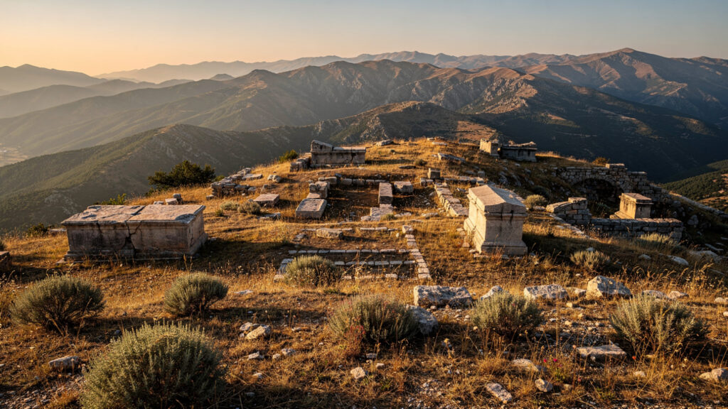
The archaeological evidence for the Athamanian capital at Argithea, the Ellinika site to the west of the current settlement where the excavations have recovered the funerary monument and the chest tombs and the ceramics and the jewelry of the Hellenistic period, is the material evidence for the organized urban life of the capital city during the period of Amynander’s kingdom. The finds are not spectacular in the sense of the Bronze Age shaft graves at Mycenae or the Minoan palace deposits at Knossos: they are the ordinary material culture of a Hellenistic period mountain town, and their interest is the interest of the material culture of the mountain kingdom whose political history the literary sources document as more significant than its archaeological remains might suggest.
The Agrafa and Its Stone Bridges
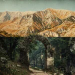
The stone arch bridges of the Epirus–Thessaly mountain border region are among the most concentrated collections of traditional engineering in the Balkans, and the bridges of the Argithea area are the most accessible examples of a construction practice that the mountain communities of northwestern Greece developed across the Ottoman period and the early modern period as the infrastructure that their terrain required.
The construction of the stone arch bridge in the mountain environment requires the combination of the engineering knowledge of the arch’s structural logic, the skill of the mason who can work the local stone into the curvature that the arch requires, and the material assessment of the stream crossing’s requirements: the width of the gorge, the depth of the water at flood stage, the foundation conditions on each bank, and the traffic load that the bridge would need to sustain. The mountain bridges of the Greek northwest encode all of these assessments in their forms, each bridge shaped by the conditions of the crossing it was designed to serve.
The Agios Minas bridges at the entrance to the village are theally designated protected monuments of the Argithea area, whose protection reflects the architectural and historical significance that the regional administration has recognized in the bridge tradition. The architectural character of the Greek mountain bridge, the single or double arch of shaped stone rising from the water level to the roadway above, the curvature of the arch that distributes the load through the stone mass to the abutments on each bank, and the visual relationship between the bridge’s white limestone and the dark water of the mountain stream, is the character that the Agios Minas bridges display in their setting.
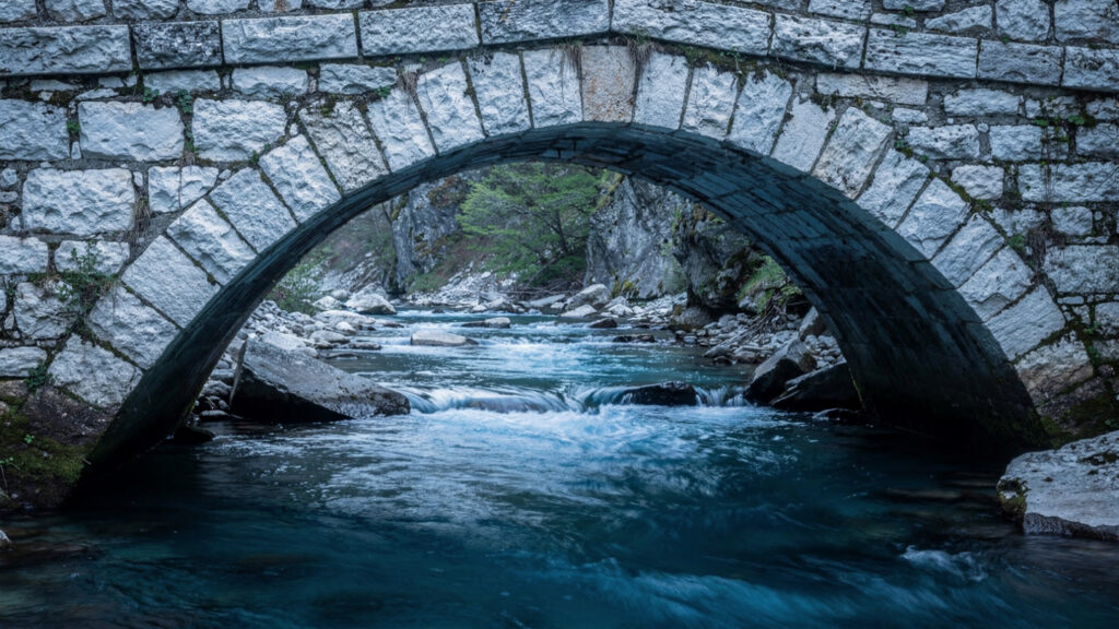
The mastoroi, the master builders who constructed the stone bridges of the Greek mountain practice, were the itinerant craftsmen whose knowledge of the bridge construction technique made them the specialists that the mountain communities engaged for the task rather than attempting to build with the general construction knowledge of the village workforce. The mastoroi traveled through the mountain communities of Epirus and Macedonia and Thessaly taking the contracts for the stone bridges and the stone churches and the more technically demanding buildings that the general construction workforce could not produce, and the quality of the surviving bridges reflects the accumulated knowledge of a craft lineage that the itinerant specialists maintained and transmitted across the generations of their practice.
The Landscape and Its Character
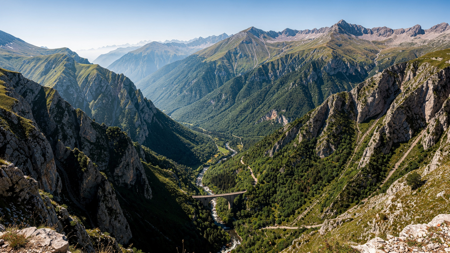
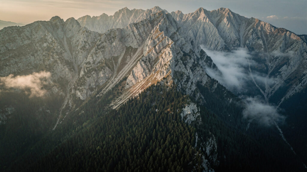
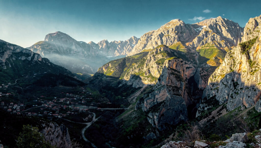
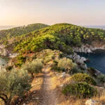
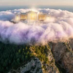
The Agrafa mountain range occupies the position between the Thessalian plain to the east and the Epirote mountain landscape to the west, in the geological zone where the Pindus range’s central massif produces the highest elevations and the deepest river valleys of the central Greek mainland. The Acheloos River, one of the longest rivers in Greece, has its headwaters in the Agrafa, and the gorge system that the river has cut through the limestone and the flysch of the mountain geology as it descends toward the Acarnanian plain is the gorge system that gives the Agrafa its dramatic landscape character.
The forest of the Agrafa is among the most extensive natural forest remaining in mainland Greece: the combination of the altitude, the high rainfall that the mountain terrain intercepts from the weather systems moving in from the Ionian, and the history of the region’s practical autonomy from the Ottoman and subsequent administrations that might otherwise have cleared the forest for agricultural use, has preserved the quality of the Agrafa forest in a condition closer to the natural mountain forest of the central Greek mainland than almost anywhere else in the country. The fir and beech forest of the upper slopes and the mixed deciduous forest of the lower elevations and the riparian forest of the river gorges together produce the botanical diversity of the Agrafa landscape, with the endemic and rare plant populations that the protected area designation the region now carries reflects.
The rivers of the Agrafa produce the cold clear water that the limestone and the high altitude and the forest cover combine to create: the Argithea streams that descend from the upper Agrafa to the Acheloos tributaries carry the quality of mountain water that the combination of the geological filter of the limestone and the biological filter of the intact forest cover produces, and the experience of the mountain stream in the Argithea landscape, the cold and the clarity and the sound of the water in the gorge, is the experience of a landscape that has been maintaining the water quality of its streams through the mechanism of the intact ecological system rather than through the water treatment infrastructure that the urban supply requires.
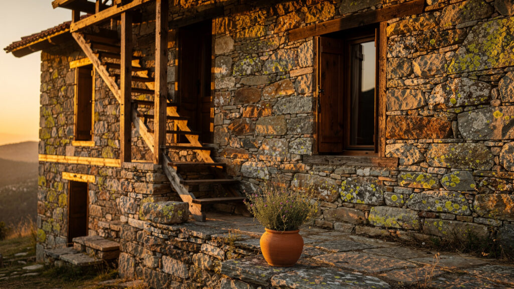
The villages of Argithea, distributed across the mountain terrain in the pattern that the water availability and the defensibility of the site and the agricultural land of the valley above sea level determined for each community, maintain the stone architecture of the mountain building tradition: the houses of dressed local stone, the exterior staircases, the proportions of the mountain house whose thick walls and small windows balance the thermal mass requirement of the cold winter months against the ventilation requirement of the warm summer months. The villages that the western and eastern routes through the municipality connect, from Antiro and Petroto and Marathos in the west to Vlasi and Petrilo and Stephaniada in the east, are the villages that the road network made accessible without changing their fundamental character as mountain communities organized around their relationships to the terrain above and the valley below.
Getting There and When to Go
Argithea is accessed primarily through Mouzaki, the town at the Thessalian plain’s edge where the mountain road begins its ascent into the Agrafa: Mouzaki is approximately thirty kilometers west of Karditsa on the road that connects the Thessalian plain to the Agrafa mountain region, and the mountain road from Mouzaki to the Argithea villages continues through the landscape transition from the plain’s edge through the foothills to the mountain proper that the altitude gain of the approach makes progressively more dramatic.
The road network within the municipality divides at the approach to the Argithea main settlement into the western route through Antiro and Petroto to Marathos and Vragkiana and the eastern route through Vlasi and Petrilo to Stephaniada, and the circuit of the two routes gives the visitor the experience of the different faces of the Argithea landscape: the western route through the denser forest and the more enclosed valley character, the eastern route through the more open terrain of the higher ridges.
The optimal visiting months are May through June for the spring flowering of the mountain vegetation and September through October for the autumn coloring and the harvest season of the Agrafa villages. July and August are accessible but the popularity of the region’s hiking trails in the peak summer months reduces the quality of solitude that the Agrafa landscape most completely provides in the shoulder seasons. The winter months, when the upper Agrafa is snow-covered and the mountain roads require the equipment of the winter mountain driving, give the landscape its most austere and most completely different character from the summer version.
The accommodation in Argithea is primarily the small family-run guesthouses and the converted stone houses that the municipality’s alternative tourism program has developed: the quality of the overnight stay in the Argithea villages, the stone building and the mountain air and the quality of the night sky that the absence of light pollution in the high mountain interior produces, is the quality that the hotel in the plain cannot provide and that justifies the distance of the approach.
What Argithea Offers
Argithea offers the combination that the Olympus Estate reader who has exhausted the standard itinerary of the organized archaeological sites and the island travel guides is looking for: a landscape of genuine natural quality, an archaeological dimension that requires the knowledge of the ancient Athamanian kingdom to appreciate, an engineering heritage of the stone bridge tradition that is genuinely significant and genuinely under-appreciated, and the quality of the unregistered mountain community that the Ottoman administration never reached and that the subsequent modernization processes have modified more slowly than the accessible regions.
It is not a landscape organized for the visitor. It is a landscape that has its own logic, maintained by its own communities, and that the visitor who arrives with the preparation of having read what the landscape actually is will find more interesting than the landscape they were expecting from the Greek Alps comparison. The Alps are somewhere else. Argithea is itself.
At Olympus Estate, Wanderlust Greece guides you across the sacred and storied terrain of the Hellenic world. Argithea was the capital of Athamania, the mountain kingdom whose last king Amynander backed Rome against Macedon and then Antiochus against Rome and lost his kingdom in the second mistake. The Agrafa mountains were never registered by the Ottoman administration. The consequence was practical autonomy across three centuries of occupation. The stone bridges were built by itinerant mastoroi who carried the engineering knowledge of the arch through the mountain communities. The fir forest is intact because the Ottoman administration never reached the upper slopes to clear it. Go in September. Take the western route first. The landscape explains itself once you know what you are looking at.


