


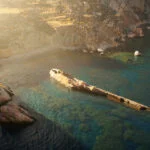

The water above it is three meters deep and clear enough to read through.
That is the first thing that arrests the mind about Pavlopetri: not the age, not the scale, not the Bronze Age streets still legible beneath the Laconian sea, but the sheer visibility of it. A snorkeler above the southeastern coast of the Peloponnese can look down and see walls. Doorways. The stone foundations of rooms where people stored oil and slept and argued about money. The ocean did not bury this city. It preserved it, held it in suspension at a depth shallow enough to be seen with the naked eye, for thirty-five hundred years.
Pavlopetri is the oldest known submerged urban settlement in the world. It predates Classical Athens by more than a millennium. It was trading across the Aegean while the Trojan War was still a generational memory away from being fought, while Linear B was still a new technology, while the civilizations that would later seem foundational were themselves still forming. And it did all of this not as a palace economy, not as a temple city organized around divine kingship, but as a port: a place whose logic was commerce, whose streets were designed for movement, whose wealth came from the sea it sat beside and the networks it maintained across it.
A City with Streets
Fokion Negris, a Greek geologist, identified the site in 1904. The world paid little attention. In 1967, marine geologist Nic Flemming dove into the bay off the village of Pavlopetri near Vatika and understood what he was looking at: not scattered ruins but a coherent urban plan, its grid still readable beneath two meters of water and three millennia of sediment.
The city covers an area equivalent to eight football fields. Within that area, archaeologists working the site across several decades identified streets, houses with internal courtyards, storage buildings, temples, individual stone tombs, and a formal cemetery positioned outside the city boundary. The houses were not single-room structures. Many appear to have been two stories, built from cut stone, arranged in semi-detached rows along paved streets. The urban organization is deliberate and consistent: this was a city that knew what it was doing.
Beneath the streets, a network of stone-lined channels managed water and waste. The civil engineering required to design and build a drainage system of this kind across an entire settlement is not the work of a society at the beginning of urban thought. It is the work of a society that has been building cities long enough to know what cities require.
In 2009, a team led by underwater archaeologist Dr. Jon Henderson of the University of Nottingham, working alongside researchers from the Australian Centre for Field Robotics, produced the first complete three-dimensional digital map of the site. Sonar scanning and photogrammetry reconstructed the city as it stood at its height. For the first time, the streets of Pavlopetri could be walked again, virtually, by anyone with access to the rendering. The city that had been visible only to divers became navigable to the world.
What the Seabed Held
The objects recovered from Pavlopetri’s streets and floors are the objects of daily life in a trading port. Pottery. Grinding stones. Storage jars. Crockery worn smooth at the rim from years of use. Large clay pithoi, the great storage vessels of the Bronze Age world, found in concentrations that indicate centralized warehousing: the management of bulk goods moving in and out of the harbor.
The goods themselves are identifiable from the vessel types. Olive oil. Wine. Textiles. Perfumes and dyes, the luxury commodities that moved along the Bronze Age trade routes connecting the Aegean islands, Minoan Crete, the Mycenaean centers of the mainland, and the eastern Mediterranean beyond. Pavlopetri sat at the intersection of these routes, small enough to have been overlooked by history, positioned precisely enough to have been essential to the commerce that history depended on.
Among the finer pottery, archaeologists found ceramic copies of expensive Minoan copper vessels. Local artisans making affordable versions of elite foreign goods: the logic is identical to what happens in any port city that has absorbed enough foreign influence to want it and enough local ingenuity to reproduce it at lower cost. The citizens of Pavlopetri were not passive recipients of Aegean culture. They were participants in it, adapting what arrived from Crete and the islands to their own materials and markets.
No inscriptions in Linear A or Linear B have been recovered from the site. Given the scale of the storage and trading operations the pithoi deposits suggest, some form of record-keeping almost certainly existed. Whether it was written, symbolic, or conducted through systems that have not survived the submersion remains an open question. The absence of text does not indicate illiteracy. It indicates that the texts, if they existed, were written on materials the sea did not preserve.
The Logic of a Port City
What Pavlopetri was not is as significant as what it was.
It was not a palace city. No structure at the site suggests a ruling elite organized around a god-king or a central administrative power of the kind visible at Mycenae or Knossos. The tombs are individual, distributed through the city, not concentrated in a royal precinct. The houses are differentiated in size but not in kind: gradations of wealth, not the categorical separation between palace and settlement that defines the great Bronze Age centers.
This was a city organized around the sea and the exchange the sea enabled. Its authority was commercial. Its population was, in the evidence available, a community of merchants, artisans, sailors, and the support economies that port cities generate: the grinders and storers and preparers whose labor made the movement of goods possible.
The parallel to modern port cities is not rhetorical. The organizational logic of Pavlopetri, a settlement whose prosperity depends on connectivity rather than conquest, on the volume of exchange rather than the concentration of agricultural surplus, is the logic of every harbor city that has operated on the same principles since. The goods change. The Bronze Age pithoi become the shipping containers of the twenty-first century. The principle, that a city at the edge of the sea derives its value from what passes through it, has not changed in four thousand years.
How the Sea Took It
The submersion of Pavlopetri is not precisely dated and not precisely understood.
The city was inhabited from at least 2800 BCE and shows evidence of continuous occupation through the Mycenaean period, with activity recorded until approximately 1000 BCE. At some point after that, the land on which it stood subsided. The Laconian coastline is seismically active: the eastern Mediterranean fault systems that run beneath the Peloponnese have produced catastrophic events across recorded history. A major earthquake struck the region in 375 CE, and some researchers associate the final submersion with this event, though the abandonment of the city appears to have preceded it by several centuries.
The most likely sequence is gradual: the land sinking incrementally over generations, the sea rising to meet the walls of houses that were still standing, the population retreating inland as the lower streets flooded and the harbor became the city itself. Not a single catastrophic moment but an extended departure, the kind that leaves no dramatic evidence precisely because it unfolds slowly enough to be managed rather than survived.
What the sea did in taking the city, it also did in keeping it. Submerged sites are protected from the forces that erase terrestrial ruins: agricultural plowing, construction, the systematic looting that attends any ruin accessible to anyone who passes by with a shovel. The walls of Pavlopetri stand because nothing with wheels or foundations has passed over them in three thousand years. The ocean that removed the city from history preserved it for the moment when the technology existed to find it again.
What It Changes
Every map of early European civilization that places the beginning of urban complexity at Mycenae or Knossos is incomplete without Pavlopetri.
The city does not replace those centers. It contextualizes them. It demonstrates that the Bronze Age Aegean was not a world of isolated palace economies, each the apex of its regional hierarchy, but a networked world of which the palaces were only the most visible nodes. Between Mycenae and Knossos and the other great centers lay a maritime infrastructure of ports and trading settlements whose names have mostly not survived, whose records were kept on materials the sea and time did not preserve, but whose function was essential to the system the palaces depended on.
Pavlopetri is one node of that infrastructure that the sea happened to preserve at a depth shallow enough to find. It stands for the dozens or hundreds of similar settlements that lined the coasts of the Bronze Age Aegean and have left no trace above the waterline.

The coast of Laconia is quiet now. The water above the old streets catches the afternoon light and holds it for a moment before releasing it to the sea floor. Three meters down, the walls of houses built before Troy fell still run along the lines their builders intended. The doorways still open in the directions they were designed to open.

The city is still there. It has been there the entire time. The sea simply kept it until we were ready to look.
At Olympus Estate, Archaeology & Ancient Sites treats no ruin as a relic. Each site is a threshold — between the world that built it and the world that inherited it. Pavlopetri did not disappear. It waited.


